Modi'in Illit
Modi'in Illit
|
||
|---|---|---|
| Hebrew transcription(s) | ||
| • ISO 259 | Modiˁin ʕillit | |

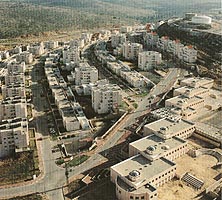
Overview of Kiryat Sefer
|
||
|
||
| Coordinates: 31°55′50″N 35°2′30″E / 31.93056°N 35.04167°ECoordinates: 31°55′50″N 35°2′30″E / 31.93056°N 35.04167°E | ||
| Region | West Bank | |
| District | Judea and Samaria Area | |
| Founded | 1994 | |
| Government | ||
| • Type | City (from 2008) | |
| • Mayor | Yaakov Gutterman | |
| Area | ||
| • Total | 4,746 dunams (4.746 km2 or 1.832 sq mi) | |
| Population (2015) | ||
| • Total | 64,179 | |
| Name meaning | Upper Modi'in | |
Modi'in Illit (Hebrew: מוֹדִיעִין עִלִּית; Arabic: موديعين عيليت, lit. "Upper Modi'in") is a Haredi Israeli settlement and city in the West Bank, situated midway between Jerusalem and Tel Aviv. Modi'in Illit was granted city status by the Israeli government in 2008. It is located six kilometres (3.7 miles) northeast of Modi'in-Maccabim-Re'ut and is often referred to as Kiryat Sefer (lit. "Book Town"), the name of its first neighborhood, established in 1994. It was built on the land of five Palestinian villages: Ni'lin, Kharbata, Saffa, Bil'in and Dir Qadis. Modi'in Illit encompasses the neighborhoods of Kiryat Sefer and Achuzat Brachfeld (Brachfeld Estates). In 2015 it had a total population of 64,179, making it the largest Jewish settlement in the area.
The international community considers Israeli settlements illegal under international law, but the Israeli government disputes this.
A place named Kiryat Sefer (also called Dvir) is mentioned several times in the Book of Joshua and in the Book of Judges. However, this place is situated south of Hebron, and the Israeli Governmental names committee rejected calling the town Kiryat Sefer as was proposed initially, electing the name Modi'in Illit.
...
Wikipedia


