Mobara
|
Mobara 茂原市 |
|||
|---|---|---|---|
| City | |||

Mobara City Hall
|
|||
|
|||
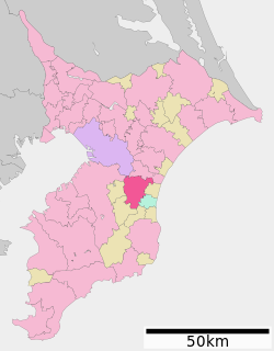
 Location of Mobara in Chiba Prefecture |
|||
| Coordinates: 35°25′42.7″N 140°17′17″E / 35.428528°N 140.28806°ECoordinates: 35°25′42.7″N 140°17′17″E / 35.428528°N 140.28806°E | |||
| Country | Japan | ||
| Region | Kantō | ||
| Prefecture | Chiba Prefecture | ||
| Area | |||
| • Total | 99.92 km2 (38.58 sq mi) | ||
| Population (December 1, 2015) | |||
| • Total | 89,655 | ||
| • Density | 897/km2 (2,320/sq mi) | ||
| Time zone | Japan Standard Time (UTC+9) | ||
| - Tree | Azalea | ||
| - Flower | Cosmos | ||
| Phone number | 0475-33-2111 | ||
| Address | 1 Dōbyō, Mobara-shi, Chiba-ken 297-8511 | ||
| Website | www |
||
Mobara (茂原市 Mobara-shi?) is a city located in Chiba Prefecture, Japan.
As of December 1, 2015, the city had an estimated population of 89,655 and a population density of 897 persons per km². The total area was 99.92 square kilometres (38.58 sq mi).
Mobara is located in an inland area of north-central Bōsō Peninsula. The elevation is low, ranging from 8–9 meters in the east, and rising to 100 meters in the west. Its proximity to the Pacific Ocean and with warming effects of the Kuroshio Current give the area a mild maritime climate, with hot, humid summers and cool, mild winters.
Chiba Prefecture
Mobara was settled from the earliest times, as evidenced by archaeological sites and shell mounds dating from the Jōmon period and Yayoi periods. The city also has examples of kofun, or burial tombs, from the Kofun period.
Mobara was the location of at least two shōen estates, the Mobara-sō and the Tachibana-sō, in the Heian period. At the beginning of the Edo period, in 1591, an extensively land survey was carried out by the Tokugawa clan.
The modern town of Mobara was created during the early Meiji period-cadastral reforms in the Chōsei District. Numerous small villages were brought together to form the present-day city of Mobara.
...
Wikipedia


