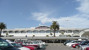
Miyazaki Airport
|
Miyazaki Airport 宮崎空港 |
|||||||||||
|---|---|---|---|---|---|---|---|---|---|---|---|
 |
|||||||||||
| Summary | |||||||||||
| Airport type | Public | ||||||||||
| Operator | Ministry of Land, Infrastructure, Transport and Tourism | ||||||||||
| Serves | Miyazaki Prefecture | ||||||||||
| Elevation AMSL | 19 ft / 6 m | ||||||||||
| Coordinates | 31°52′38″N 131°26′55″E / 31.87722°N 131.44861°ECoordinates: 31°52′38″N 131°26′55″E / 31.87722°N 131.44861°E | ||||||||||
| Map | |||||||||||
| Location in Japan | |||||||||||
| Runways | |||||||||||
|
|||||||||||
| Statistics (2015) | |||||||||||
|
|||||||||||
|
Source: Japanese Ministry of Land, Infrastructure, Transport and Tourism
|
|||||||||||
| Passengers | 2,976,563 |
|---|---|
| Cargo (metric tonnes) | 8,516 |
| Aircraft movement | 42,045 |
Miyazaki Airport (宮崎空港 Miyazaki Kūkō?) (IATA: KMI, ICAO: RJFM) is an airport located 3.2 km (2.0 mi) south southeast of Miyazaki, a city in the Miyazaki Prefecture of Japan.
The second floor has the head office of Solaseed Air.
Link Airs, a Fukuoka-based regional airline startup, planned to begin service to the airport in 2014. However, the company filed for bankruptcy before launching any flights.
The airport is connected to various locations by bus. Also, there is a railway line, the Miyazaki Kūkō Line, which connects the airport with the city center of Miyazaki and northern cities of the prefecture.
The airport opened in 1943 as an Imperial Japanese Navy base during World War II, and was a major base for "kamikaze" units beginning in February 1945, sending a total of 47 aircraft on suicide missions during operations such as the Battle of Okinawa.
On October 1969, All Nippon Airways Flight 104 overran a runway at Miyazaki Airport by 132 metres. All four crew and 49 passengers survived.
...
Wikipedia

