Miyako Island
| Native name: Miyakojima (宮古島?) | |
|---|---|

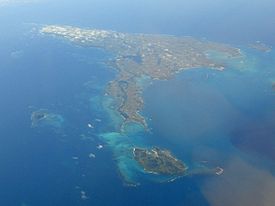
Aerial view of Miyako-jima from northwest.
|
|
| Geography | |
| Location | Okinawa Prefecture |
| Coordinates | 24°46′N 125°19′E / 24.767°N 125.317°E |
| Archipelago | Miyako Islands |
| Area | 158.87 km2 (61.34 sq mi) |
| Highest elevation | 114.8 m (376.6 ft) |
| Highest point | Nakao |
| Administration | |
|
Japan
|
|
| Demographics | |
| Population | 55,914 (30 October 2006) |
| Pop. density | 275.4 /km2 (713.3 /sq mi) |
Miyako-jima (宮古島?, Miyako: Myaaku (ミャーク?); Okinawan: Naaku (ナーク?)) is the largest and the most populous island among the Miyako Islands of Okinawa Prefecture, Japan. Miyako-jima is administered as part of the City of Miyakojima, which includes not only Miyako-jima, but also five other populated islands.
Miyako-jima lies approximately 300 kilometres (190 mi) southwest of Okinawa Island and 400 kilometres (250 mi) east of Taipei, Taiwan. With an area of 158.70 square kilometres (61.27 sq mi), Miyako is the fourth-largest island in Okinawa Prefecture. The island is triangular in shape and is composed of Ryukyuan limestone. Miyako-jima is subject to drought and is frequently struck by typhoons.
Miyako-jima is well known for its beauty, particularly the Eastern Cape (東平安名岬 Higashi-hennazaki?), which is considered by many as one of the most beautiful spots in Japan. Other notable locations include Maehama beach, the German Cultural Center, Painagama Beach, and the sights on Irabu-jima. There are three islands close by which are connected by bridges to Miyako-jima, Irabujima (as of early 2015), Ikemajima (池間島 Ikema-jima?), and Kurimajima (来間島 Kurima-jima?). The Miyako language, one of several Ryukyuan languages, is spoken here.
...
Wikipedia

