Missouri Ozarks
| Ozarks | |
|---|---|
| Ozark Mountains, Ozark Plateau | |

View of the Ozarks from the Buffalo National River, Newton County, Arkansas
|
|
| Highest point | |
| Peak | Buffalo Lookout |
| Elevation | 2,561 ft (781 m) |
| Coordinates | 35°51′49″N 93°29′35″W / 35.86361°N 93.49306°WCoordinates: 35°51′49″N 93°29′35″W / 35.86361°N 93.49306°W |
| Geography | |
| Country | United States |
| State/Province |
Arkansas Kansas Missouri Oklahoma |
| Geology | |
| Age of rock | Proterozoic |
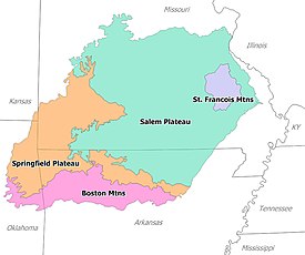
The Ozarks, also referred to as the Ozark Mountains, Ozarks Mountain Country, and the Ozark Plateau, is a physiographic and geologic highland region of the central United States, primarily in Arkansas, Missouri, and Oklahoma. The Ozarks cover a significant portion of southern Missouri, extending as far northeast as the southwestern suburbs of St. Louis. In Arkansas, a large portion is contained within the northwestern and northcentral region. Much smaller pieces of the Ozarks extend westward into northeastern Oklahoma and extreme southeastern Kansas.
The Shawnee Hills of southwest Illinois, which lie near the eastern edge of this region, are commonly called the "Illinois Ozarks," but are generally not considered part of the true Ozarks.
Although sometimes referred to as the Ozark Mountains, the region is actually a high and deeply dissected plateau. Geologically, the area is a broad dome around the Saint Francois Mountains. The Ozark Highlands area, covering nearly 47,000 square miles (122,000 km2), is by far the most extensive mountainous region between the Appalachians and the Rocky Mountains. Together, the Ozarks and Ouachita Mountains form an area known as the U.S. Interior Highlands, and are sometimes referred to collectively. For example, the ecoregion called Ozark Mountain Forests includes the Ouachita Mountains, although the Arkansas River Valley and the Ouachitas, both south of the Boston Mountains, are not usually considered part of the Ozarks.
...
Wikipedia

