Mississippi River System
| Mississippi River System | |
| The Western Rivers | |
|
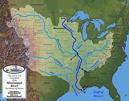
Map of the course, watershed, and major tributaries of the Mississippi River
|
|
| Country | United States |
|---|---|
|
Mississippi River Tributaries
|
|
The Mississippi River System, also referred to as the Western Rivers, is a mostly riverine network of the United States which includes the Mississippi River and connecting waterways. The Mississippi River is the largest drainage basin in the United States. In the United States, the Mississippi drains about forty-one percent of the country's rivers.
From the perspective of natural geography and hydrology, the system consists of the Mississippi River itself and its numerous natural tributaries and distributaries. The major tributaries are the Arkansas, Illinois, Missouri, Ohio and Red rivers. Given their flow volumes, major Ohio River tributaries like the Allegheny, Tennessee, and Wabash rivers are considered important tributaries to the Mississippi system. Before the Mississippi River reaches the Gulf of Mexico, it runs into its distributary, the Atchafalaya River.
From the perspective of modern commercial navigation, the system includes the above as well as navigable inland waterways which are connected by artificial means. Important connecting waterways include the Illinois Waterway, the Tennessee-Tombigbee Waterway, and the Gulf Intracoastal Waterway. This system of waterways is maintained by the U.S. Army Corps of Engineers with a project depth of between 9 and 12 feet (2.7 – 3.7 m) to accommodate barge transportation, primarily of bulk commodities.
...
Wikipedia


