Minton, Shropshire
| Minton | |
|---|---|
 Minton, Shropshire |
|
| Minton shown within Shropshire | |
| OS grid reference | SO429907 |
| Civil parish | |
| Unitary authority | |
| Ceremonial county | |
| Region | |
| Country | England |
| Sovereign state | United Kingdom |
| Post town | CHURCH STRETTON |
| Postcode district | SY6 |
| Dialling code | 01694 |
| Police | West Mercia |
| Fire | Shropshire |
| Ambulance | West Midlands |
| EU Parliament | West Midlands |
| UK Parliament | |
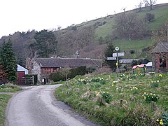
Minton is a hamlet in Shropshire, England.
It is located in the parish of Church Stretton, 2½ miles southwest of the market town of Church Stretton. A historic settlement, it is situated on a foothill of the Long Mynd at around 240m above sea level. As of 2010, there are around 12 dwellings in the hamlet.
Three lanes lead out from the hamlet: one to the A49 road, one mile southeast at Marshbrook; another lane leads to the hamlet of Hamperley, which is also in Church Stretton parish; and Little Stretton is one mile to the northeast.
The place name is from Welsh mynydd meaning 'hill' and Old English tun meaning 'settlement', 'town'. The hamlet has largely retained its Anglo-Saxon layout, with a patchwork of plots and haphazard narrow lanes. There are remains of a motte, which dates from either Anglo-Saxon or Norman times. It was a township and Royal manor, held by King Edward prior to the Norman conquest. It is mentioned in the Domesday Book.
Today the hamlet consists of farms and cottages and is agricultural in character. It is designated a conservation area and there are 5 Listed buildings in the hamlet – Long Mynd House, Ivanhoe, Manor Farmhouse, Well Cottage, and Minton House.
There is an outdoors activity centre located on the lane between Minton and Hamperley, the Longmynd Adventure Camp, with overnight accommodation and camping ground.
...
Wikipedia

