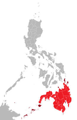
Mindanao Island

Mindanao mainland in red;
its associated islands in maroon |
|
|
Location within the Philippines
|
|
| Geography | |
|---|---|
| Location | Southeast Asia |
| Coordinates | 8°00′N 125°00′E / 8.000°N 125.000°ECoordinates: 8°00′N 125°00′E / 8.000°N 125.000°E |
| Archipelago | Philippines |
| Adjacent bodies of water | |
| Major islands | |
| Area | 104,530 km2 (40,360 sq mi) |
| Area rank | 19th |
| Highest elevation | 3,144 m (10,315 ft) |
| Highest point | Mount Apo |
| Administration | |
| Regions | |
| Provinces |
List
|
| Largest settlement | Davao City (pop. 1,632,991) |
| Demographics | |
| Demonym | Mindanaoans |
| Population | 21,968,174 (Mindanao island group) (2010) |
| Pop. density | 243 /km2 (629 /sq mi) |
| Ethnic groups |
List
|
Mindanao (![]() i/mɪndəˈnaʊ/; Tagalog pronunciation: [minˈdɐnaw]) is the second largest and southernmost major island in the Philippines. It is also the name of one of the three island groups in the country (the other two being Luzon and the Visayas), consisting of the island of Mindanao and smaller outlying islands. As of the 2010 census, the island's population itself is 20,281,545 people, while the Mindanao island group has 21,968,174 inhabitants.
i/mɪndəˈnaʊ/; Tagalog pronunciation: [minˈdɐnaw]) is the second largest and southernmost major island in the Philippines. It is also the name of one of the three island groups in the country (the other two being Luzon and the Visayas), consisting of the island of Mindanao and smaller outlying islands. As of the 2010 census, the island's population itself is 20,281,545 people, while the Mindanao island group has 21,968,174 inhabitants.
Davao City is the most populous city in Mindanao hosting 1,632,991 people, followed by Zamboanga City (pop. 861,799), Cagayan de Oro City (pop. 675,950) and General Santos City (594,446) based on the 2015 Census of Population.
Parts of south-western Mindanao island group, particularly the provinces of Maguindanao, Basilan, Lanao del Sur, Sulu, and Tawi-Tawi (part of the Autonomous Region of Muslim Mindanao (ARMM)), are home to a sizeable Muslim population, making the island group, along with Palawan, the only area of the Philippines with a significant Muslim presence. The island has seen a communist insurgency as well as armed Moro separatist movements.
...
Wikipedia

