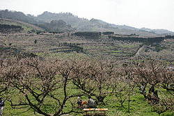
Minabe, Wakayama
|
Minabe みなべ町 |
|
|---|---|
| Town | |

Minabe Plum-grove, as known for a plum grove site in Japan
|
|
 Location of Minabe in Wakayama Prefecture |
|
| Coordinates: 33°46′21″N 135°19′14″E / 33.77250°N 135.32056°ECoordinates: 33°46′21″N 135°19′14″E / 33.77250°N 135.32056°E | |
| Country | Japan |
| Region | Kansai |
| Prefecture | Wakayama Prefecture |
| Government | |
| • Mayor | Yoshimasa Kotani |
| Area | |
| • Total | 120.26 km2 (46.43 sq mi) |
| Population (November 30, 2011) | |
| • Total | 14,150 |
| • Density | 117.66/km2 (304.7/sq mi) |
| Time zone | Japan Standard Time (UTC+9) |
| Symbols | |
| • Tree | Ubame oak (Quercus phillyraeoides) |
| • Flower | Ume (Prunus mume) |
| • Bird | Japanese bush warbler (Cettia diphone) |
| • Fish | Japanese sardine (Sardinops melanostictus) |
| Phone number | 0739-72-2015 |
| Address | 742 Shiba, Minabe-chō, Hidaka-gun, Wakayama-ken 645-0002 |
| Website | Minabe Town |
Minabe (みなべ町 Minabe-chō?) is a small town located in Hidaka District, Wakayama Prefecture in the Kansai region of Japan. Situated on a small bay of the Pacific ocean and surrounded by mountains, it is a quiet and picturesque farming community of about 14,000 people. Its location has been mentioned in ancient texts since the 8th century, but the basic land area was incorporated in 1889. After a series of village mergers, the present area of Minabe was formed in 2004. Minabe is known for its high-quality apricots, or Japanese apricot. It is also known for a high-quality charcoal called Binchōtan, has good fishing waters, and produces a variety of agricultural goods.
Minabe is located at the southernmost edge of Hidaka District in central Wakayama Prefecture. The main part of Minabe, including the train station, government buildings, and business district, lies around the basin of the Minabe River as it flows into Minabe Bay on the Pacific Ocean. There are three distinguishing features of Minabe Bay: Kashima Island situated approximately 1 km offshore, a long non-swimming beach that runs parallel to the central business district, and two prominent rocky points at either end. The central area of town is largely flat and comprises the majority of houses and people. It is moderately populated, with many cultivated fields and buildings.
To the west-northwest of central Minabe is the Iwashiro region which is centered on the Iwashiro River Basin. This area is lightly populated and a mixture of farmland and forested mountains. It also features sections of non-swimming beaches.
Following the Minabe River northeast one comes to the Kamiminabe region. This area is partly mountainous and comprises the majority of the town’s ume trees. Following the river farther upwards, the valley becomes increasingly narrow and forested, with little ground suitable for cultivation or houses. The path of the Minabe River here is narrow, no more than 30m across. There is little to nothing in the way of buildings or cultivated fields. Approximately 8 kilometers from the center of town is the lightly populated region of Takagi which features some farmland and houses. A further 6 kilometers up the river valley is the even smaller region of Kiyokawa, which is the end of Minabe. The highest point is located here: 768m.
...
Wikipedia

