Milpa Alta
| Milpa Alta | ||
|---|---|---|
| Delegación | ||
|
||
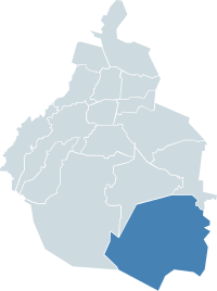
 Milpa Alta within the Federal District |
||
| Country | Mexico | |
| Federal entity | D.F. | |
| Established | 1903 | |
| Named for | Monastic community | |
| Seat | Av. México, esq. Constitución S/N Col. Villa Milpa Alta | |
| Government | ||
| • Jefe delegacional | Francisco García Flores (PRD) | |
| Area | ||
| • Total | 286.234 km2 (110.516 sq mi) | |
| Population 2010 | ||
| • Total | 130,582 | |
| • Density | 460/km2 (1,200/sq mi) | |
| Time zone | Central Standard Time (UTC-6) | |
| • Summer (DST) | Central Daylight Time (UTC-5) | |
| Postal codes | 04000 – 04980 | |
| Area code(s) | 55 | |
| Website | http://www.milpa-alta.df.gob.mx/ | |
Milpa Alta is one of the 16 boroughs into which Mexico's Federal District is divided. It lies in the southeast corner of the Distrito Federal, bordering the State of Mexico and Morelos. It is the second largest and most rural of all the boroughs with the lowest population. It is also one of the most traditional areas of the city, with over 700 religious and secular festivals during the year and an economy based on agriculture and food processing, especially the production of nopal cactus, barbacoa and mole sauce.
The borough of Milpa Alta is located in the southeast of the Federal District of Mexico City bordering the boroughs of Xochimilco, Tláhuac and Tlalpan, with the state of Morelos to the south and the State of Mexico to the west. It has the second largest territorial extension after Tlalpan, occupying 268.6km2.
The terrain is rugged mostly consisting of volcanic peak along with some small flat areas mostly formed in the Cenozoic Era . City officials have classified the entire borough as a conservation zone, important for its role as an aquifer recharge area as well as its forests. Forest, farmland and grazing areas constitute 98.1% of the total surface area.
It has an average altitude of 2,420 meters above sea level with altitudes varying between 2,300 and 3,600. It is part of the Trans-Mexican Volcanic Belt and the Sierra Chichinautzin volcanic mountain chain, which separates the Federal District from the state of Morelos. The borough is divided into three zones: Ajusco-Teuhtli, the lowest elevations, Topilejo-Milpa Alta in the medium range and Cerro-Tlicuaya at the highest elevations. The main elevations are volcanic and include Cuautzin (3,510), Tulmiac, Ocusacayo (3,220), La Comalera (3,230), San Bartolo (3,200), Tláloc (3,510), Chichinautzin (3,470), Yecahuazac, Quimixtepec, El Oclayuca (3,140), El Pajonal (3,100), El Ocotécatl (3,480), Acopiaxco (3,320), Tetzacoatl (3,310), Tehutli (2,800) Cilcuayo (3,580), Nepanapa (3,460), Texalo (3,560), Oclayuca (3,390), San Miguel (2,988) .
...
Wikipedia

