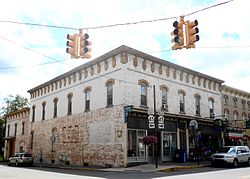
Millheim, Pennsylvania
| Millheim, Pennsylvania | |
|---|---|
| Borough | |

Post office
|
|
 Map showing Millheim in Centre County |
|
 Map showing Centre County in Pennsylvania |
|
| Map showing Millheim in Centre County | |
| Coordinates: 40°53′28″N 77°28′33″W / 40.89111°N 77.47583°WCoordinates: 40°53′28″N 77°28′33″W / 40.89111°N 77.47583°W | |
| Country | United States |
| State | Pennsylvania |
| County | Centre |
| Settled | 1797 |
| Incorporated (borough) | 1879 |
| Government | |
| • Mayor | Lauralee Snyder |
| Area | |
| • Total | 1.3 sq mi (3.4 km2) |
| Elevation | 696 ft (212 m) |
| Population (2010) | |
| • Total | 904 |
| • Density | 684.8/sq mi (264.5/km2) |
| Time zone | Eastern (EST) |
| • Summer (DST) | EDT (UTC) |
| Zip code | 16854 |
| Area code(s) | 814 |
| Website | www |
Millheim is a borough in Centre County, Pennsylvania, United States. It is part of the State College, Pennsylvania Metropolitan Statistical Area. The population was 904 at the 2010 census. The Millheim Historic District, which includes 176 contributing buildings, was listed on the National Register of Historic Places in 1986.
Millheim is located at 40°53′28″N 77°28′33″W / 40.89111°N 77.47583°W (40.890981, -77.475954).
According to the United States Census Bureau, the borough has a total area of 1.3 square miles (3.4 km2), all of it land.
The town was named for having a millhouse situated along Elk Creek, the town still features the mill's raceway which flows through the downtown area.
As of the census of 2010, there were 904 people, 377 households, and 251 families residing in the borough. The population density was 684.8 people per square mile (264.5/km²). There were 417 housing units at an average density of 315.9 per square mile (122.0/km²). The racial makeup of the borough was 98.2% White, 0.1% Black or African American, 0.1% Native American, 0.1% other, and 1.5% from two or more races.
...
Wikipedia

