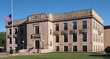
Mille Lacs County, Minnesota
| Mille Lacs County, Minnesota | |
|---|---|

|
|
 Location in the U.S. state of Minnesota |
|
 Minnesota's location in the U.S. |
|
| Founded | May 23, 1857 |
| Named for | Mille Lacs Lake |
| Seat | Milaca |
| Largest city | Princeton |
| Area | |
| • Total | 682 sq mi (1,766 km2) |
| • Land | 572 sq mi (1,481 km2) |
| • Water | 109 sq mi (282 km2), 16% |
| Population (est.) | |
| • (2015) | 25,788 |
| • Density | 46/sq mi (18/km²) |
| Congressional district | 8th |
| Time zone | Central: UTC-6/-5 |
| Website | www |
Mille Lacs County (/mᵻlˈlæks/ məl-LAKS) is a county located in the U.S. state of Minnesota. As of the 2010 census, the population was 26,097. Its county seat is Milaca. The county was founded in 1857, and its boundary was expanded in 1860.
Mille Lacs County is included in the Minneapolis-St. Paul-Bloomington, MN-WI Metropolitan Statistical Area.
A portion of the Mille Lacs Indian Reservation is in the county.
The name Mille Lacs, meaning "thousand lakes" in French, comes from Mille Lacs Lake (French: Grand lac du Pays des Mille Lacs), largest lake in the Brainerd Lakes Area as the area was called "Region of Thousand Lakes" (Pays des Mille Lacs) in French.
Mille Lacs County was organized on May 23, 1857, cleaving off the easternmost portion of Benton County, Minnesota. The original Mille Lacs County consisted of the portion of the contemporary Mille Lacs County east of the west branch of the Rum River and two townships now part of Isanti County, adjacent to Mille Lacs County. In 1858, the 12 townships forming the contemporary southern 10 townships of Mille Lacs County and the 2 northwestern townships in Isanti County were organized apart from either Benton or Mille Lacs County to form Monroe County, leaving the northern "Square Top-knot" as the Mille Lacs County. In 1860, Monroe and Mille Lacs Counties merged. Shortly thereafter, the two southeastern townships were transferred to Isanti County, forming the contemporary boundaries for the county.
...
Wikipedia
