Mifflinville, Pennsylvania
| Mifflinville, Pennsylvania | |
|---|---|
| Census-designated place | |

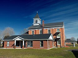
Mifflinville United Methodist Church
|
|
 Location within Columbia County |
|
| Location within the state of Pennsylvania | |
| Coordinates: 41°1′56″N 76°18′28″W / 41.03222°N 76.30778°WCoordinates: 41°1′56″N 76°18′28″W / 41.03222°N 76.30778°W | |
| Country | United States |
| State | Pennsylvania |
| County | Columbia |
| Township | Mifflin |
| Area | |
| • Total | 1.38 sq mi (3.57 km2) |
| • Land | 1.37 sq mi (3.55 km2) |
| • Water | 0.008 sq mi (0.02 km2) |
| Elevation | 510 ft (160 m) |
| Population (2010) | |
| • Total | 1,253 |
| • Density | 915/sq mi (353.1/km2) |
| Time zone | Eastern (EST) (UTC-5) |
| • Summer (DST) | EDT (UTC-4) |
| ZIP code | 18631 |
| FIPS code | 42-49312 |
| GNIS feature ID | 1213288 |
Mifflinville is an unicorporated community and census-designated place (CDP) in Columbia County, Pennsylvania, United States. The population was 1,253 at the 2010 census. It is part of the Bloomsburg–Berwick Micropolitan Statistical Area.
Because there was little transportation reaching Mifflinville until the North and West Branch Railroad was built in 1855, there have been few industries in Mifflinville. However, a church was built in Mifflinville in 1831.
Mifflinville is located in east-central Columbia County at 41°1′43″N 76°18′26″W / 41.02861°N 76.30722°W (41.028617, -76.307175), in the northern part of Mifflin Township.
According to the United States Census Bureau, the CDP has a total area of 1.38 square miles (3.57 km2), of which 1.37 square miles (3.55 km2) is land and 0.01 square miles (0.02 km2), or 0.49%, is water. Mifflinville is on the south side of the Susquehanna River, several miles downriver (southwest) from Berwick. The eastern part of Mifflinville is mostly farmland, while the western part is residential. Mifflinville's terrain is almost entirely flat.
...
Wikipedia

