Middleboro, Massachusetts
| Middleborough, Massachusetts Middleboro |
||
|---|---|---|
| Town | ||

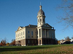
Town Hall
|
||
|
||
| Motto: Cranberry Capital of the World | ||
 Location in Plymouth County in Massachusetts |
||
| Coordinates: 41°53′22″N 70°53′39″W / 41.88944°N 70.89417°WCoordinates: 41°53′22″N 70°53′39″W / 41.88944°N 70.89417°W | ||
| Country | United States | |
| State | Massachusetts | |
| County | Plymouth | |
| Settled | 1660 | |
| Incorporated | 1669 | |
| Government | ||
| • Type | Open town meeting | |
| Area | ||
| • Total | 72.2 sq mi (186.9 km2) | |
| • Land | 69.1 sq mi (178.9 km2) | |
| • Water | 3.1 sq mi (8.0 km2) | |
| Elevation | 141 ft (43 m) | |
| Population (2010) | ||
| • Total | 23,116 | |
| • Density | 320/sq mi (120/km2) | |
| Time zone | Eastern (UTC-5) | |
| • Summer (DST) | Eastern (UTC-4) | |
| ZIP code | 02346 | |
| Area code(s) | 508 / 774 | |
| FIPS code | 25-40850 | |
| GNIS feature ID | 0618346 | |
| Website | http://www.middleborough.com | |
Middleborough (frequently written as Middleboro) is a town in Plymouth County, Massachusetts, United States. The population was 23,116 at the 2010 census. For geographic and demographic information on the village of Middleborough Center, please see the article Middleborough Center, Massachusetts. In the summer of 2007, Middleborough became the proposed location for a controversial future resort casino, sponsored by the Wampanoag Tribe of Mashpee, Massachusetts.
The town was first settled by Europeans in 1661 as Nemasket, later changed to Middlebury, and officially incorporated as Middleborough in 1669. The name Nemasket came from a Native American settlement along the small river that now bears the same name. Nemasket may have meant "place of fish", due to the large amount of herring that migrate up the river each spring. There are no contemporary records that indicate the name Middlebury was taken from a place in England, and changed to the more modern Middleborough. The names Middlebury and Middleborough were actually derived from the city of Middelburg, Zeeland, the westernmost province of the Netherlands. Middelburg was an international intellectual center and economic powerhouse. The English religious dissenters called the Brownists developed their governance institutions in Middelburg before emigrating on the Mayflower, and were the earliest settlers of Middleborough where their town and church governance ethics were continued.
During King Philip's War (1675–76), the town's entire populace took shelter within the confines of a fort constructed along the Nemasket River. The site is located behind the old junior high school (now a kindergarten), and is marked by a state historical commission marker along Route 105. Before long, the fort was abandoned and the population withdrew to the greater shelter of the Plymouth Colony; in their absence, the entire village was burned to the ground, and it would be several years before the town would be refounded. Western Middleborough broke away in 1853 and formed the town of Lakeville, taking with it the main access to the large freshwater lakes there, including Assawompset Pond.
...
Wikipedia

