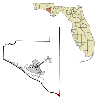
Mexico Beach
| Mexico Beach, Florida | |
|---|---|
| City | |

Mexico Beach waterfront
|
|
 Location in Bay County and the state of Florida |
|
| Coordinates: 29°56′29″N 85°24′23″W / 29.94139°N 85.40639°WCoordinates: 29°56′29″N 85°24′23″W / 29.94139°N 85.40639°W | |
| Country |
|
| State |
|
| County |
|
| Incorporated (city) | 1967 |
| Government | |
| • Mayor | Al Cathey |
| Area | |
| • Total | 1.83 sq mi (4.73 km2) |
| • Land | 1.77 sq mi (4.60 km2) |
| • Water | 0.05 sq mi (0.13 km2) |
| Elevation | 13 ft (4 m) |
| Population (2010) | |
| • Total | 1,072 |
| • Estimate (2016) | 1,190 |
| • Density | 670.80/sq mi (258.93/km2) |
| Time zone | Central (CST) (UTC-6) |
| • Summer (DST) | CDT (UTC-5) |
| ZIP code | 32410 |
| Area code(s) | 850 |
| FIPS code | 12-44300 |
| GNIS feature ID | 0286747 |
| Website | www |
Mexico Beach is a city in Bay County, Florida, United States. The population was 1,072 at the 2010 census. It is part of the Panama City–Lynn Haven area.
Mexico Beach is located at 29°56′29″N 85°24′23″W / 29.941336°N 85.406361°W.
According to the United States Census Bureau, the city has a total area of 1.8 square miles (4.7 km2), of which 1.8 square miles (4.6 km2) is land, and 0.04 square miles (0.1 km2), or 2.84%, is water.
The following diagram represents localities within a 20-mile (32 km) radius of Mexico Beach.
As of the census of 2010, there were 1,072 people, 563 households, and 320 families residing in the city. The population density was 595.6 inhabitants per square mile (233.0/km²). There were 1,852 housing units at an average density of 1,028.9 per square mile (402.6/km²). The racial makeup of the city was 93.1% White, 1.9% African American, 0.4% Native American, 0.7% Asian, 0.0% Native Hawaiian or other Pacific Islander, 0.8% some other race, and 3.1% from two or more races. Hispanic or Latino of any race were 2.6% of the population.
...
Wikipedia
