Mevaseret Zion
Mevasseret Zion
|
||
|---|---|---|
| Hebrew transcription(s) | ||
| • ISO 259 | Mbaśśert Çiyon | |
| • Also spelled | Mevasseret Ziyyon (official) | |

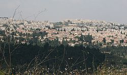
View of Mevaseret from Rekhes Halilim
|
||
|
||
| Coordinates: 31°48′N 35°9′E / 31.800°N 35.150°ECoordinates: 31°48′N 35°9′E / 31.800°N 35.150°E | ||
| District | Jerusalem | |
| Founded | 1951 | |
| Government | ||
| • Type | Local council | |
| • Head of Municipality | Yoram Shimon | |
| Area | ||
| • Total | 6,390 dunams (6.39 km2 or 2.47 sq mi) | |
| Population (2015) | ||
| • Total | 24,409 | |
| Name meaning | Herald of Zion (from Isaiah 40:9) | |
Mevasseret Zion (Hebrew: מְבַשֶּׂרֶת צִיּוֹן) is a suburb of Jerusalem. Mevasseret Zion is composed of two distinct townships, Maoz Zion and Mevasseret Yerushalayim—under the jurisdiction of one local council. The newer neighborhoods of Mevasseret Zion were not part of either settlement.
Mevasseret Zion is located on a mountain ridge 750 meters above sea level, on the outskirts of Jerusalem. It is ten kilometers from the city, straddling both sides of the Jerusalem–Tel Aviv highway. In 2015 it had a population of 24,409, spread over 15 neighborhoods. It is the wealthiest municipality per capita in the Jerusalem District. Mevasseret Zion's current Mayor is Yoram Shimon.
Due to its strategic location, settlement in the area of Mevasseret Zion goes back to antiquity. The Romans built a fortress there, known as Castellum. On the ruins of this fortress, the Crusaders built a castle, Castellum Belveer, of which no trace remains. Belveer is mentioned in a letter from Eraclius, Patriarch of Jerusalem, dated September 1187, in which he describes the slaughter of Christians "by the sword of Mafumetus the Unbeliever and his evil worshipper Saladin" and the Arab conquest of the town, which was renamed al-Qastal.
During the British Mandate of Palestine, the British referred to this district as "The Castle". The Arabs called it "al-Qastal", pronouncing the "t." The Jews called it "HaCastel" ("the Castel").
In the 1948 Palestine War, battles took place here as Arabs and Jews fought for control of Qastal, which overlooked the main Tel Aviv-Jerusalem highway. Qastal exchanged hands several times in the course of the fighting. The tides turned when the Arab commander Abd al-Qadir al-Husayni was killed. Many of the Arabs left their positions to attend al-Husayni's funeral at the Al-Aqsa Mosque on Friday, April 9. That same day, Qastal fell to the Yishuv forces, virtually unopposed.
...
Wikipedia


