Metropolitan Borough of Hackney
| Hackney | |
|---|---|

Hackney Town Hall
|
|
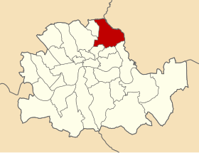
 Hackney within the County of London |
|
| History | |
| • Origin | Hackney parish |
| • Created | 1900 |
| • Abolished | 1965 |
| • Succeeded by | London Borough of Hackney |
| Status | Metropolitan borough |
| Government | Hackney Borough Council |
| • HQ | Mare Street |
| • Motto | Justitia Turris Nostra (Justice is our tower) |
 Arms of the borough council |
|
The Metropolitan Borough of Hackney was a Metropolitan borough of the County of London from 1900 to 1965. Its area became part of the London Borough of Hackney.
The borough was one of twenty-eight metropolitan boroughs created by the London Government Act 1899. It was the successor to the vestry of the parish of Hackney, which had been the local authority since 1855.
The boundaries of Hackney with the neighbouring boroughs were adjusted slightly in 1900: Hackney gained the east side of Bethune Road from Stoke Newington and the south side of Balls Pond Road from Islington; it lost the west side of Southgate Road to Islington. The boundary with Shoreditch was altered to run along the Regents Canal, Albion Road and Brougham Road, while the boundary with Bethnal Green, which had formed a straight line, was changed to follow the line of Gore Road. A further adjustment was made in 1908, when areas were exchanged with Tottenham Urban District, Middlesex. It had a border with Leyton Urban District (a municipal borough from 1926) in Essex to the east and to the north, from which it was divided by Hackney Marshes.
The metropolitan borough included the districts of Hackney, Upper and Lower Clapton, Homerton, Dalston and Kingsland. It also included Stoke Newington Common, and the entire eastern side of Stoke Newington High Street.
...
Wikipedia
