Metro Subway
| Metro Subway | |
|---|---|
 |
|

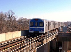
Metro Subway train entering the Reisterstown Plaza station, bound for Owings Mills
|
|
| Overview | |
| Type | Rapid transit |
| Status | Operational |
| Locale | Baltimore, Maryland |
| Termini |
Owings Mills (west) Johns Hopkins Hospital (east) |
| Stations | 14 |
| Daily ridership | 40,100 (Q2 2016) |
| Ridership | 12,948,400 (2015) |
| Operation | |
| Opened | November 21, 1983 |
| Owner | Maryland Transit Administration |
| Operator(s) | Maryland Transit Administration |
| Character | Underground, surface, elevated |
| Depot(s) | 5801 Wabash Avenue |
| Rolling stock | 100 Budd cars |
| Technical | |
| Line length | 15.4 mi (24.8 km) |
| Track length | 34 mi (55 km) |
| Number of tracks | 2 |
| Track gauge | 4 ft 8 1⁄2 in (1,435 mm) standard gauge |
| Electrification | Third rail (700 VDC) |
| Operating speed | 70 mph (110 km/h) |
| Highest elevation | 28 ft (8.5 m) |
The Baltimore Metro Subway, known locally as the Metro Subway, The Subway, or the Baltimore Metro, is a rapid transit line serving the greater area of Baltimore, Maryland, in the United States, and operated by the Maryland Transit Administration. Despite its name, less than half of the line is underground; most of the line outside of the central city is elevated or at surface grade.
The origins of the Metro Subway lie in the Baltimore Area Mass Transportation Plan, published in 1965, which envisioned six rapid transit lines radiating out from a central city loop. Planning studies from 1968 proposed a rail transit system 71 mi (114 km) long.
As the vision was translated into reality, the original concept was trimmed to a 28 mi (45 km) system in the Phase 1 plan, published in 1971. This plan involved two of the original six lines: a northwest line from Downtown Baltimore to Owings Mills and a south line to Glen Burnie and the airport. Phase 1 was approved for funding by the Maryland General Assembly in 1972. In response to crime concerns of Anne Arundel County residents, the MTA eliminated the south line from Phase 1 plans in 1975.
When the Baltimore Metro opened on November 21, 1983, only the "Northwest" line of the 1965 plan had come to fruition. This 7.6 mi (12.2 km) segment provided service between Charles Center in Downtown Baltimore and Reisterstown Plaza in the northwest section of the city. In 1987, a 6.1 mi (9.8 km) addition extended the line from Reisterstown Road Plaza to Owings Mills in Baltimore County, much of it running in the median of I-795. A further extension of 1.6 mi (2.5 km) from Charles Center to Johns Hopkins Hospital was opened in 1994.
Once the project was completed in 1995, the total cost for the Metro Subway was $1.392 billion.
The current system is 15.4 mi (24.8 km) long, including 6.2 mi (10 km) underground, 2.2 mi (3.5 km) elevated, and 7.0 mi (11.3 km) at grade level (with roadways separated). Eight of its 14 stations are underground, at depths of 52 ft (16 m) to 112 ft (34 m) below street level. Its elevated stations stand from 25 ft (7.6 m) to 28 ft (8.5 m) above ground.
...
Wikipedia
