Metal Township, Franklin County, Pennsylvania
| Metal Township, Franklin County, Pennsylvania |
|
|---|---|
| Township | |

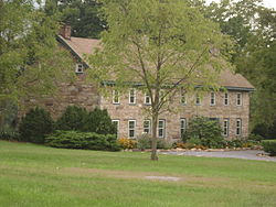
Mt. Pleasant Iron Works House, a historic site in the township
|
|
 Map of Franklin County, Pennsylvania highlighting Metal Township |
|
 Map of Franklin County, Pennsylvania |
|
| Country | United States |
| State | Pennsylvania |
| County | Franklin |
| Settled | 1763 |
| Incorporated | 1795 |
| Area | |
| • Total | 44.6 sq mi (115.5 km2) |
| • Land | 44.5 sq mi (115.3 km2) |
| • Water | 0.08 sq mi (0.2 km2) |
| Population (2010) | |
| • Total | 1,866 |
| • Density | 42/sq mi (16.2/km2) |
| Time zone | Eastern (EST) (UTC-5) |
| • Summer (DST) | EDT (UTC-4) |
| Area code(s) | 717 |
Metal Township is a township in Franklin County, Pennsylvania, United States. The population was 1,866 at the 2010 census.
The Bridge in Metal Township, Carrick Furnace, and Mt. Pleasant Iron Works House are listed on the National Register of Historic Places.
The township is located along the western edge of Franklin County, bordered to the west by Huntingdon and Fulton counties. The western border of the township (and county line) follows the crest of Tuscarora Mountain, while the eastern border follows the crest of Kittatinny Mountain. The space between the mountains is known as Path Valley and comprises the settled portion of the township. The valley is drained by the West Branch Conococheague Creek, part of the Potomac River watershed.
Pennsylvania Route 75 runs the length of the township, through the center of Path Valley. From south to north, it passes through the unincorporated communities of Richmond Furnace, Metal, Fannettsburg (the largest community in the township), Springtown, and Willow Hill. Interstate 76, the Pennsylvania Turnpike, runs through the northern part of the township, with access from Exit 189, the Willow Hill Interchange. The turnpike passes through the Tuscarora Mountain Tunnel at the western border of the township.
...
Wikipedia
