Merrifield, Virginia
| Merrifield, Virginia | |
|---|---|
| Census-designated place | |

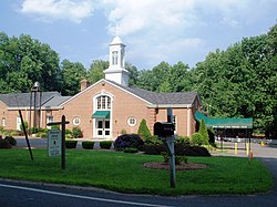
A church in Merrifield
|
|
 Location of Merrifield in Fairfax County, Virginia |
|
| Location of Merrifield in Fairfax County, Virginia | |
| Coordinates: 38°52′23″N 77°14′35″W / 38.87306°N 77.24306°WCoordinates: 38°52′23″N 77°14′35″W / 38.87306°N 77.24306°W | |
| Country | United States |
| State | Virginia |
| County | Fairfax |
| Area | |
| • Total | 2.72 sq mi (7.05 km2) |
| • Land | 2.71 sq mi (7.03 km2) |
| • Water | 0.008 sq mi (0.02 km2) |
| Elevation | 361 ft (110 m) |
| Population (2010) | |
| • Total | 15,212 |
| • Density | 5,602/sq mi (2,163.0/km2) |
| Time zone | Eastern (EST) (UTC-5) |
| • Summer (DST) | EDT (UTC-4) |
| Area code(s) | 703 |
| FIPS code | 51-51192 |
| GNIS feature ID | 1493280 |
Merrifield is a census-designated place (CDP) in Fairfax County, Virginia, United States. The population was 15,212 at the 2010 census.
Merrifield is located in eastern Fairfax County at 38°52′23″N 77°14′35″W / 38.87306°N 77.24306°W (38.873144, −77.242994). It is bounded by I-66 on the north, the Capital Beltway on the east, Arlington Boulevard (U.S. Route 50) on the south, and Nutley Street (Virginia State Highway 243) on the west. Neighboring communities are Oakton to the west, the town of Vienna to the north, Dunn Loring to the northeast, Idylwood and West Falls Church to the east, Annandale at the southeast corner of Merrifield, Woodburn and Mantua to the south, and the city of Fairfax to the southwest. Downtown Washington, D.C. is 13 miles (21 km) to the east.
...
Wikipedia


