Merowe Dam
| Merowe Dam | |
|---|---|
 |
|
|
Sudan
|
|
| Location | Merowe, Sudan |
| Coordinates | 18°40′08″N 32°03′01″E / 18.66889°N 32.05028°ECoordinates: 18°40′08″N 32°03′01″E / 18.66889°N 32.05028°E |
| Status | Operational |
| Construction began | 2004 |
| Opening date | March 3, 2009 |
| Construction cost | €1.2 billion |
| Dam and spillways | |
| Impounds | River Nile |
| Height | 67 m (220 ft) |
| Length | 9 km (5.6 mi) |
| Reservoir | |
| Creates | Merowe Reservoir |
| Total capacity | 12.5 km3 (10,100,000 acre·ft) |
| Power station | |
| Turbines | 10 × 125 MW (168,000 hp) Francis-type |
| Installed capacity | 1,250 MW (1,680,000 hp) |
| Annual generation | 5.5 TWh (20 PJ) |
|
Website http://www.merowedam.gov.sd/ |
|
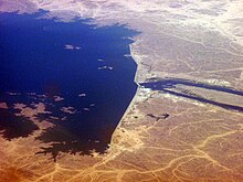
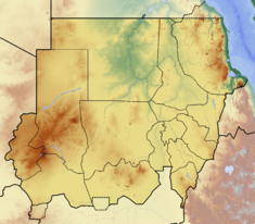
The Merowe Dam, also known as Merowe High Dam, Merowe Multi-Purpose Hydro Project or Hamdab Dam, is a large dam near Merowe Town in northern Sudan, about 350 kilometres (220 mi) north of the capital Khartoum. Its dimensions make it the largest contemporary hydropower project in Africa. It is situated on the river Nile, close to and inundating the 4th Cataract where the river divides into multiple smaller branches with large islands in between. Merowe is a city about 40 kilometres (25 mi) downstream from the construction site at Hamdab. The main purpose for building the dam was the generation of electricity.
The dam has a length of about 9 kilometres (5.6 mi) and a crest height of up to 67 metres (220 ft). It consists of concrete-faced rockfill dams on each river bank (the right bank dam is the largest part of the project, 4.3 km long and 53m high; the left bank is 1590 metres long and 50 metres high), an 883-metre (2,897 ft)-long 67-metre (220 ft)-high earth-core rockfill dam (the 'main dam') in the left river channel, and a live water section in the right river channel (sluices, spillway and a 300-metre power intake dam with turbine housings). It contains a reservoir of 12.5 cubic kilometres (10,100,000 acre·ft), or about 20% of the Nile's annual flow; the intended reservoir level is 300 metres above sea level, with the Nile level downstream of the dam being about 265 metres. The reservoir lake is planned to extend 174 kilometres (108 mi) upstream.
The powerhouse is equipped with ten 125 megawatts (168,000 hp) Francis turbines, each one designed for a nominal discharge rate of 300 cubic metres per second, and each one driving a 150 MVA, 15 kV synchronous generator. The planners expect an annual electricity yield of 5.5 terawatt-hours (20 PJ), corresponding to an average load of 625 megawatts (838,000 hp), or 50% of the rated load. To utilize the extra generation capacity, the Sudanese power grid will be upgraded and extended as part of the project, with about 500 kilometres (310 mi) of new 500 kV aerial transmission line across the Bayudah Desert to Atbara, continuing to Omdurman/Khartoum, as well as about 1,000 kilometres (620 mi) of 220 kV lines eastwards to Port Sudan and westwards along the Nile, connecting to Merowe, Dabba and Dongola.
...
Wikipedia

