Mercier–Hochelaga-Maisonneuve
| Mercier-Hochelaga-Maisonneuve | ||
|---|---|---|
| Borough of Montreal | ||

Marché Maisonneuve, a major farmer's market, with the statue La Fermière by Alfred Laliberté in the foreground.
|
||
|
||
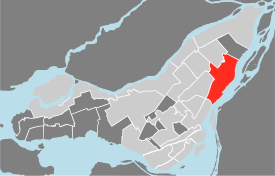
 Map of the island of Montreal, with Mercier-Hochelaga-Maisonneuve in red. |
||
| Country | Canada | |
| Province | Quebec | |
| City | Montreal | |
| Electoral Districts Federal |
Hochelaga La Pointe-de-l'Île Honoré-Mercier |
|
| Provincial |
Hochelaga-Maisonneuve Bourget Anjou–Louis-Riel |
|
| Government | ||
| • Borough Mayor | Réal Ménard (CM) | |
| • Federal MP(s) |
Marjolaine Boutin-Sweet (NDP) Mario Beaulieu (BQ) Pablo Rodríguez (LPC) |
|
| • Quebec MNA(s) |
Carole Poirier (PQ) Maka Kotto (PQ) Lise Thériault (PLQ) |
|
| Area | ||
| • Total | 25.4 km2 (9.8 sq mi) | |
| Population | ||
| • Total | 131,483 | |
| • Density | 5,174.5/km2 (13,402/sq mi) | |
| Time zone | EST (UTC-5) | |
| • Summer (DST) | EDT (UTC-4) | |
| Area code(s) | 514 | |
Mercier–Hochelaga-Maisonneuve is a borough of Montreal, Quebec.
In 1860, Hochelaga developed as a village counting a little more than 1000 inhabitants. In 1874, Hudon — a cotton factory- moved in. Two years later, the North railway was extended through Hochelaga (the railway was renamed the Canadian Pacific in 1881) further catalyzing its industrial development and encouraging urbanization. In December 1883, Hochelaga was annexed to the city of Montreal against the demands of proprietors in Hochelaga. In response, they founded the village Maisonneuve and in only 15 years Maisonneuve became the 5th industrial slum of Canada. However, the area flourished. By 1918, however, the area was saddled with debt and aging factories and infrastructure. It was annexed to Montreal the same year.
Two years later, in 1920, many factories closed and moved east to Mercier. Mercier was an agglomeration of old villages: Beau-Rivage, Longue-Pointe and Tétreaultville. It was annexed to Montreal in 1910, before Maisonneuve. In 1960, the construction of the Autoroute 25 saw the demolition of many residential buildings in Mercier and divided it into two districts: Mercier-Ouest and Mercier-Est. Factories would continue to shut down well into the 1980s, leaving the borough ridden with poverty and a high concentration of welfare, especially in Hochelaga-Maisonneuve. This has led to a population exodus, high crime rates and a general negative portrait of the area. It is, still today, often seen as the French ghetto of Montreal.
Located in the east end of the Island of Montreal, it was part of the City of Montreal prior to the 2002 municipal mergers. It is composed of the Hochelaga-Maisonneuve, Mercier-Ouest and Mercier-Est areas. Each area has roughly the same population, but they differ in their commercial and social characteristics. The western region of the borough is composed of older districts while the Northern and Eastern regions have gone through a more recent urbanization. The borough is mainly composed of working class Québécois with a notable presence of Vietnamese immigrants in western regions and Italians as well as French immigrants to the North and East.
...
Wikipedia

