Mendocino National Forest
| Mendocino National Forest | |
|---|---|
|
IUCN category VI (protected area with sustainable use of natural resources)
|
|

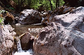
Rattlesnake Creek
|
|
|
Map of the United States
|
|
| Nearest city | Willows, California and Covelo, California |
| Coordinates | 39°33′45″N 122°48′45″W / 39.56250°N 122.81250°WCoordinates: 39°33′45″N 122°48′45″W / 39.56250°N 122.81250°W |
| Area | 913,306 acres (3,696.02 km2) |
| Established | 1907 |
| Governing body | U.S. Forest Service / Department of Agriculture |
| Website | Mendocino National Forest |
The Mendocino National Forest is located in the Coastal Mountain Range in northwestern California and comprises 913,306 acres (3,696 km2). It is the only national forest in the state of California without a major paved road entering it. There are a variety of recreational opportunities — camping, hiking, mountain biking, paragliding, backpacking, boating, fishing, hunting, nature study, photography, and off-highway vehicle travel.
The forest lies in parts of six counties. In descending order of forestland area they are Lake, Glenn, Mendocino, Tehama, Trinity, and Colusa counties. Forest headquarters are located in Willows, California. There are local ranger district offices in Covelo, Upper Lake, and Willows.
The forest includes four wilderness areas:
The Sanhedrin and Yuki wildernesses were signed into law on October 17, 2006. This legislation, entitled "Northern California Coastal Wild Heritage Wilderness Act", added areas to both the Yolla Bolly - Middle Eel Wilderness and Snow Mountain Wilderness, and established the two new wilderness areas in the Mendocino National Forest.
Rivers include: Eel River, Rice Fork Eel River, Middle Fork Eel River, Black Butte River, and Stony Creek (Sacramento River).
...
Wikipedia

