Rice Fork
| Rice Fork | |
|---|---|

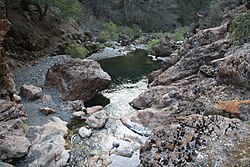
Rice Fork at Crabtree Hot Springs
|
|
| Location in California | |
| Coordinates: 39°17′23.59″N 122°49′19.98″W / 39.2898861°N 122.8222167°W | |
| Country | United States |
| State | California |
| County | Lake County |
| Elevation | 2,257 ft (688 m) |
Coordinates: 39°17′23.59″N 122°49′19.98″W / 39.2898861°N 122.8222167°W
The Rice Fork is a 22.7-mile-long (36.5 km) tributary of the Eel River in Lake County, California. The Rice Fork begins on the upper northwest side of Goat Mountain, on the Colusa-Lake County line, at an elevation of over 6,000 feet (1,800 m). It quickly descends the steep western slope of the mountain, then bends northward, and flows northwesterly down a narrow winding steep walled canyon for about 18 miles (29 km), crossing two forest roads and adding many tributaries, ending its journey at the southern tip of Lake Pillsbury, at a varied elevation around 1,800 feet (550 m), depending on the lake level. Before the construction of Scott Dam in the 1920s, which formed Lake Pillsbury, the Rice Fork ran directly into the Eel River. It is one of Lake County's longest streams.
The many tributaries to Rice Fork are Salt Creek, French Creek, Parramore Creek, Bevans Creek, Bear Creek, Packsaddle Creek, Willow Creek, Deer Creek, Rice Creek, and Soda Creek.
In the 1860s, there was a very dry year in the Sacramento Valley. A man by the name of Rice and some neighbors brought horses and mules up to Rice Valley, and used it and adjoining territory for the fine pasture. Rice Valley was their headquarters. Rice was active in that area for only a few years, but Rice Valley, Rice Creek, and the Rice Fork took his name.
At one time, an Indian trail went from the hot springs down the Rice Fork canyon to the mouth of the river where it entered Gravelly Valley, then crossed the river at the upper end of the valley, then went up Squaw Valley Creek to the north of Big Squaw Valley and over the ridge to the Indian village at Bloody Rock. A portion of this trail is now under Lake Pillsbury.
...
Wikipedia

