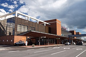
Memanbetsu Airport
|
Memanbetsu Airport 女満別空港 Memanbetsu Kūkō |
|||||||||||
|---|---|---|---|---|---|---|---|---|---|---|---|
 |
|||||||||||
| Summary | |||||||||||
| Airport type | Public | ||||||||||
| Operator | Government | ||||||||||
| Location | Memanbetsu, Ōzora, Hokkaidō, Japan | ||||||||||
| Elevation AMSL | 109 ft / 33 m | ||||||||||
| Coordinates | 43°52′50″N 144°09′51″E / 43.88056°N 144.16417°ECoordinates: 43°52′50″N 144°09′51″E / 43.88056°N 144.16417°E | ||||||||||
| Map | |||||||||||
| Location in Japan | |||||||||||
| Runways | |||||||||||
|
|||||||||||
| Statistics (2015) | |||||||||||
|
|||||||||||
|
Source: Japanese Ministry of Land, Infrastructure, Transport and Tourism
|
|||||||||||
| Passengers | 757,103 |
|---|---|
| Cargo (metric tonnes) | 1,588 |
| Aircraft movement | 10,221 |
Memanbetsu Airport (女満別空港 Memanbetsu Kūkō?) (IATA: MMB, ICAO: RJCM) is an airport in the Memanbetsu section of Ōzora, a town in Hokkaidō, Japan. The airport is close to Shiretoko National Park and consistently has over one million passengers per year.
The current airfield was opened in April 1985, replacing the original Memanbetsu Airport closer to the city centre. The runway at the new airport was extended to its current length in 2000. The airport was located in the Town of Memanbetsu until 2006, when a merger consolidated Memanbetsu and the Village of Higashimokoto into the Town of Ōzora.
In 2011, the Hokkaido government announced that landing fees would be waived for international charter flights using the airport in an attempt to lure more overseas tourists to the region.
...
Wikipedia

