Melton South, Victoria
|
Melton South Melbourne, Victoria |
|||||||||||||
|---|---|---|---|---|---|---|---|---|---|---|---|---|---|

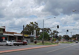
Shopping strip, Exford Road
|
|||||||||||||
| Coordinates | 37°42′11″S 144°34′19″E / 37.70306°S 144.57194°ECoordinates: 37°42′11″S 144°34′19″E / 37.70306°S 144.57194°E | ||||||||||||
| Population | 8,916 (2011 census) | ||||||||||||
| Postcode(s) | 3338 | ||||||||||||
| Location | |||||||||||||
| LGA(s) | City of Melton | ||||||||||||
| State electorate(s) | Melton | ||||||||||||
| Federal Division(s) | Gorton | ||||||||||||
|
|||||||||||||
Melton South is a suburb of Melbourne, Victoria, Australia, 35 km west of Melbourne's Central Business District. Its local government area is the City of Melton. At the 2011 Census, Melton South had a population of 8,916.
The Post Office opened on 1 January 1917 when Melton South was a sparsely populated rural area.
The Melton Train Station is located within Melton South. Rail is the major form of public transport connecting the satellite city of Melton with the Melbourne Central Business District and surrounding suburbs. The station is located on the Ballarat railway line and is served by V/Line trains. It is the terminus of the Melton line of the Melbourne metropolitan train service. Bus services 453, 455, 457, 458 and 459 connect Melton South and the station to the rest of Melton.
Melton South has two shopping districts: one located on Exford Road; the other on Station Road. The centre on Station Road contains a Coles Supermarket, chemist and a range of fresh food providers.
There are a number of parks in Melton South, including Blackwood Drive Reserve, Melton South Oval and Mount Carberry, a small hill located in a recreational reserve among suburban housing. There is also currently a Country Fire Authority station located there. A cycle path follows Toolern Creek to the east of the suburb: Toolern Creek Trail
The area is home to many educational facilities
Primary State Schools:
Catholic Primary Schools:
...
Wikipedia

