Meløy
| Meløy kommune | |||
|---|---|---|---|
| Municipality | |||
 |
|||
|
|||
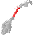
 Meløy within Nordland |
|||
| Coordinates: 66°47′17″N 13°40′33″E / 66.78806°N 13.67583°ECoordinates: 66°47′17″N 13°40′33″E / 66.78806°N 13.67583°E | |||
| Country | Norway | ||
| County | Nordland | ||
| District | Salten | ||
| Administrative centre | Ørnes | ||
| Government | |||
| • Mayor (2011) | Per Swensen (H) | ||
| Area | |||
| • Total | 873.89 km2 (337.41 sq mi) | ||
| • Land | 798.45 km2 (308.28 sq mi) | ||
| • Water | 75.44 km2 (29.13 sq mi) | ||
| Area rank | 127 in Norway | ||
| Population (2011) | |||
| • Total | 6,650 | ||
| • Rank | 145 in Norway | ||
| • Density | 8.3/km2 (21/sq mi) | ||
| • Change (10 years) | -2.4 % | ||
| Demonym(s) | Meløyfjerding | ||
| Time zone | CET (UTC+1) | ||
| • Summer (DST) | CEST (UTC+2) | ||
| ISO 3166 code | NO-1837 | ||
| Official language form | Bokmål | ||
| Website | www |
||
|
|
|||
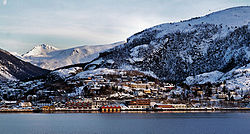
Meløy is a municipality in Nordland county, Norway. It is part of the Salten traditional region. The administrative centre of the municipality is the village of Ørnes. Other villages include Eidbukta, Neverdal, Glomfjord, Halsa, Reipå, and Ågskardet.
The municipality is situated just to the north of the Arctic Circle on Norway's west coast. It encompasses the island of Meløya and some 700 other islands of various sizes around the Meløyfjorden, Glomfjorden, and Holandsfjorden in the south, along with a stretch of mainland coast.
The municipality of Meløy was established on 1 January 1884 when the northern district of the municipality of Rødøy was separated to become the new municipality of Meløy. The initial population of Meløy was 2,696. The municipal borders have not changed since then.
The municipality (originally the parish) is named after the island of Meløya (Old Norse: Mjǫlva), since the first church (Meløy Church) was built there. The old name of the island is probably derived from mjǫl which means "flour" or "meal" (referring to fine sand on the beaches of the island). The last element øy which means "island" was added to the name around 1500. Historically, the name was spelled Melø.
The coat-of-arms is from modern times; they were granted on 7 December 1984. The arms show a yellow poppy plant (Papaver radicatum subglobosum) on a blue background. The village is near the second largest glacier in continental Norway, the Svartisen (black ice), and the plant is one of the plants growing closest to the ice. The colors symbolize the blue glacial ice and the yellow flowers.
...
Wikipedia


