Meinisberg
| Meinisberg | ||
|---|---|---|

Meinisberg municipal administration building
|
||
|
||
| Coordinates: 47°10′N 7°21′E / 47.167°N 7.350°ECoordinates: 47°10′N 7°21′E / 47.167°N 7.350°E | ||
| Country | Switzerland | |
| Canton | Bern | |
| District | Biel/Bienne | |
| Area | ||
| • Total | 4.42 km2 (1.71 sq mi) | |
| Elevation | 445 m (1,460 ft) | |
| Population (Dec 2015) | ||
| • Total | 1,328 | |
| • Density | 300/km2 (780/sq mi) | |
| Postal code | 2554 | |
| SFOS number | 0390 | |
| Surrounded by | Büren an der Aare, Lengnau, Pieterlen, Safnern | |
| Website |
www SFSO statistics |
|
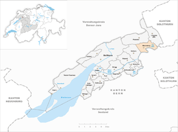
Meinisberg is a municipality in the Biel/Bienne administrative district in the canton of Bern in Switzerland.
Meinisberg is first mentioned in 1332 as Meynesberg. The municipality was formerly known by its French name Montmenil, however, that name is no longer used.
The area has been settled since the Mesolithic and Neolithic ages, as finds near the Scheidwegen section of Meinisberg indicate.La Tène and Roman artifacts have been found near the Steinen section and a High Middle Ages wooden castle was found near Reibenwald. From the Late Middle Ages Meinisberg was ruled from Pieterlen which was under the authority of the Prince-Bishop of Basel. In 1816, it came under the authority of Bern and in 1833 became an independent community. At this time it was still part of the parish of Pieterlen. When the Nidau-Büren canal was built (1865–75), the Aare River now ran past Meinisberg. The community grew due to its location on the edge of the Naturschutzgebiets Häftli (Natural Park) and ease of reaching Biel/Bienne from Meinisberg.
Meinisberg has an area of 4.42 km2 (1.71 sq mi). Of this area, 2.41 km2 (0.93 sq mi) or 54.5% is used for agricultural purposes, while 1.11 km2 (0.43 sq mi) or 25.1% is forested. Of the rest of the land, 0.66 km2 (0.25 sq mi) or 14.9% is settled (buildings or roads), 0.23 km2 (0.089 sq mi) or 5.2% is either rivers or lakes and 0.04 km2 (9.9 acres) or 0.9% is unproductive land.
Of the built up area, housing and buildings made up 7.9% and transportation infrastructure made up 5.2%. Out of the forested land, all the forested land area is covered with heavy forests. Of the agricultural land, 45.5% is used for growing crops and 7.2% is pastures, while 1.8% is used for orchards or vine crops. Of the water in the municipality, 5.0% is in lakes and 0.2% is in rivers and streams.
...
Wikipedia


