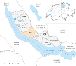
Meilen
| Meilen | ||
|---|---|---|
 |
||
|
||
| Coordinates: 47°16′N 8°38′E / 47.267°N 8.633°ECoordinates: 47°16′N 8°38′E / 47.267°N 8.633°E | ||
| Country | Switzerland | |
| Canton | Zürich | |
| District | Meilen | |
| Area | ||
| • Total | 11.94 km2 (4.61 sq mi) | |
| Elevation | 420 m (1,380 ft) | |
| Population (Dec 2015) | ||
| • Total | 13,515 | |
| • Density | 1,100/km2 (2,900/sq mi) | |
| Postal code | 8706 | |
| SFOS number | 0156 | |
| Localities | Bergmeilen, Dorfmeilen, Feldmeilen, Obermeilen | |
| Surrounded by | Egg, Herrliberg, Horgen, Oberrieden, Uetikon am See, Wädenswil | |
| Twin towns | Ebes (Hungary), Policka (Czech Republic) | |
| Website |
www SFSO statistics |
|
Meilen is a municipality in the district of Meilen in the canton of Zürich in Switzerland.
Archaeological findings in Meilen date back more than 4,000 years. In January 1854 the level of lake Zürich was particularly low and the locals took the chance to gain some land. During this undertaking prehistoric objects from the Pfyn, Horgen and early Bronze Age cultures were unearthed providing clear evidence of early settlement.
The locals also unearthed coins from Roman times (1st to 3rd century AD). One of the Roman roads connected Turicum (Zürich) with places up to Chur and passed Meilen. Many findings were discovered during more recent road building.
Parts of Meilen were possessions of monasteries, including the monastery of St. Gallen, the ones of Einsiedeln and Säckingen, or the more local Grossmünster of Zürich. Meilen is first mentioned between 820-880 as Meilana. It is guessed that this goes back to a gallic name Mediolanum.
The coats of arms shows two castle towers which represent the castle of Friedberg, the local castle. The castle was built around 1200 but extended in the 14th century. Some remains are still visible, including the fountain which reaches down 29 metres. Winegrowing in Meilen dates back for centuries.
In 1384 Meilen became a bailiwick of Zürich. Thanks to the reeve Meilen enjoyed relative autonomy until 1798. Since the Middle Ages local trade and handicraft was established in Meilen. There were at least four mills to support the local agriculture. Towards the end of the 18th century, industrialisation arrived in Meilen in form of textiles, but this form of production disappeared in the 19th century. With the arrival of the railway in 1894 local trade and industry blossomed. The ferry to Horgen was opened in 1933.
Meilen has an area of 11.9 square kilometers (4.6 sq mi). Of this area, 46.9% is used for agricultural purposes, while 24.4% is forested. Of the rest of the land, 27.2% is settled (buildings or roads) and the remainder (1.4%) is non-productive (rivers, glaciers or mountains). In 1996[update] housing and buildings made up 21.4% of the total area, while transportation infrastructure made up the rest (5.8%). Of the total unproductive area, water (streams and lakes) made up 0.2% of the area. As of 2007[update] 26.5% of the total municipal area was undergoing some type of construction.
...
Wikipedia


