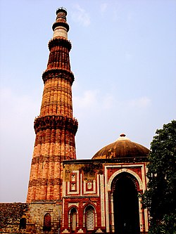
Mehrauli
| Mehrauli | |
|---|---|
| neighbourhood | |

|
|
| Coordinates: 28°30′57″N 77°10′39″E / 28.51583°N 77.17750°ECoordinates: 28°30′57″N 77°10′39″E / 28.51583°N 77.17750°E | |
| Country | India |
| State | Delhi |
| District | South West district |
| Government | |
| • MLA | Naresh Yadav |
| Languages | |
| • Official | Hindi, English |
| Time zone | IST (UTC+5:30) |
| PIN | 110 030 |
| Telephone code | 011 |
| Vehicle registration | DL-xx |
Mehrauli is a neighbourhood in the South West district of Delhi in India. It represents a constituency in the legislative assembly of Delhi. The area is located close to Gurgaon and next to Vasant Kunj. Naresh Yadav of Aam Aadmi Party is the current MLA from Mehrauli.
Mehrauli is one of the seven ancient cities that make up the present state of Delhi. The Lal Kot fort was constructed by the Tanwar chief Anangpal I around 731 AD and expanded by AnangPal II in the 11th century, who shifted his capital to Lal Kot from Kannaujs The Tanwars were defeated by the Chauhans in the 12th century. Prithviraj Chauhan further expanded the fort and called it Qila Rai Pithora. He was defeated and killed in 1192 by Mohammed Ghori, who put his general Qutb-ud-din Aybak in charge and returned to Afghanistan. Subsequently in 1206, after the death of Mohammed Ghori, Qutubuddin enthroned himself as the first Sultan of Delhi. Thus Delhi became the capital of the Mamluk dynasty of Delhi (Slave dynasty), the first dynasty of Muslim sultans to rule over northern India. Mehrauli remained the capital of the Mamluk dynasty which ruled until 1290. During the Khilji dynasty, the capital shifted to Siri.
...
Wikipedia

