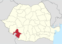
Mehedinţi County
|
Mehedinți County Județul Mehedinți |
||
|---|---|---|
| County | ||
|
||
 |
||
| Coordinates: 44°38′N 22°53′E / 44.63°N 22.88°ECoordinates: 44°38′N 22°53′E / 44.63°N 22.88°E | ||
| Country | Romania | |
| Development region | Sud-Vest | |
| Historical region | Oltenia, Banat | |
| Capital | Drobeta-Turnu Severin | |
| Area | ||
| • Total | 4,933 km2 (1,905 sq mi) | |
| Area rank | 30th | |
| Population (2011) | ||
| • Total | 254,570 | |
| • Rank | 39th | |
| • Density | 52/km2 (130/sq mi) | |
| Telephone code | (+40) 252 or (+40) 352 | |
| ISO 3166 code | RO-MH | |
| Website |
County Council Prefecture |
|
Mehedinți (Romanian pronunciation: [meheˈdint͡sʲ]) is a county (județ) of Romania on the border with Serbia and Bulgaria. It is mostly located in the historical province of Oltenia, with one municipality (Orșova) and three communes (Dubova, Eșelnița and Svinița) located in the Banat. The county seat is Drobeta-Turnu Severin.
In 2011, it had a population of 254,570 and the population density was 51.6/km².
This county has a total area of 4,933 km².
In the North-West there are the Mehedinți Mountains with heights up to 1500 m, part of the Western end of the Southern Carpathians.
The heights decrease towards the East, passing through the hills to a high plain - the Western end of the Romanian Plain.
In the South the Danube flows, forming a wide valley, with channels and ponds. Another important river is the Motru River in the East side, an affluent of the Jiu River. Also, in the West side there is the Cerna River forming a passage between the Oltenia region and the Banat region.
The energetic sector is highly developed in the county, on the Danube being two big hydro electrical power plants (Iron Gates I and Iron Gates II). Also in NE of Drobeta-Turnu Severin there is a heavy water complex (Romag Prod).
...
Wikipedia

