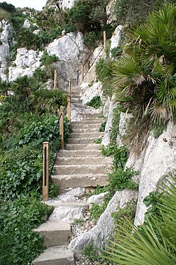
Mediterranean Steps
| Mediterranean Steps | |
|---|---|

The steps were refurbished and made safe in 2007
|
|
| Location | Upper Rock Nature Reserve, Gibraltar |
| Designation | Nature Trail |
| Elevation | |
| Highest point | Lord Airey's Battery, 400 m (1,300 ft) |
| Hiking details | |
| Season | All year |
| Sights | Levant Battery, Lord Airey's Battery, Goat's Hair Twin Caves, Strait of Gibraltar |
| Hazards | lack of water, vertigo, worn path |
Coordinates: 36°07′30″N 5°20′35″W / 36.125034°N 5.343172°W
Mediterranean Steps is a path and nature trail in the British Overseas Territory of Gibraltar. One of the footpaths of Gibraltar, the path is located entirely within the Upper Rock Nature Reserve and was built by the British military but is now used by civilians as a pedestrian route linking Martin's Path to Lord Airey's Battery near the summit of Rock of Gibraltar. The path offers views over the Strait of Gibraltar, Windmill Hill, Europa Point, the Great Sand Dune, Gibraltar's east side beaches, the Mediterranean Sea and the Spanish Costa del Sol.
The Mediterranean Steps were built as part of the military communications system built by the British to allow access to their various defence posts at the southern end of the Rock. At the highest point of the steps are the two 9.2 inch guns of Lord Airey's Battery and O'Hara's Battery. Other gun emplacements and ancillary buildings dating back to World War II are evident along the route.
...
Wikipedia
