Medford, New Jersey
| Medford, New Jersey | |
|---|---|
| Township | |
| Township of Medford | |

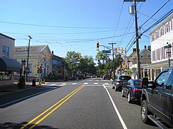
Downtown Medford at Main Street (CR 541) and Union Street
|
|
 Medford Township highlighted in Burlington County. Inset map: Burlington County highlighted in the State of New Jersey. |
|
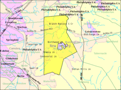
 Census Bureau map of Medford Township, New Jersey |
|
| Coordinates: 39°51′51″N 74°49′21″W / 39.864269°N 74.822471°WCoordinates: 39°51′51″N 74°49′21″W / 39.864269°N 74.822471°W | |
| Country |
|
| State |
|
| County | Burlington |
| Incorporated | March 1, 1847 |
| Named for | Medford, Massachusetts |
| Government | |
| • Type | Faulkner Act Council-Manager |
| • Body | Township Council |
| • Mayor | Jeff Beenstock (R, term on council ends December 31, 2017) |
| • Manager | Katherine Burger |
| • Clerk | Katherine Burger |
| Area | |
| • Total | 39.929 sq mi (103.416 km2) |
| • Land | 38.921 sq mi (100.804 km2) |
| • Water | 1.008 sq mi (2.611 km2) 2.52% |
| Area rank | 57th of 566 in state 8th of 40 in county |
| Elevation | 52 ft (16 m) |
| Population (2010 Census) | |
| • Total | 23,033 |
| • Estimate (2015) | 23,414 |
| • Rank | 108th of 566 in state 5th of 40 in county |
| • Density | 591.8/sq mi (228.5/km2) |
| • Density rank | 429th of 566 in state 27th of 40 in county" |
| Time zone | Eastern (EST) (UTC-5) |
| • Summer (DST) | Eastern (EDT) (UTC-4) |
| ZIP code | 08055 |
| Area code | 609 exchanges: 654, 714, 953 |
| FIPS code | 3400545120 |
| GNIS feature ID | 0882083 |
| Website | www |
Medford is a township in Burlington County, New Jersey, United States. As of the 2010 United States Census, the township's population was 23,033, reflecting an increase of 780 (+3.5%) from the 22,253 counted in the 2000 Census, which had in turn increased by 1,727 (+8.4%) from the 20,526 counted in the 1990 Census.
Medford was incorporated as a township by an act of the New Jersey Legislature on March 1, 1847, from portions of Evesham Township, based on the results of a referendum held that day. Portions of the township were taken to form Shamong Township (February 19, 1852), Lumberton Township (March 14, 1860) and Medford Lakes (May 17, 1939).
The area known as Medford was sold to Samual Coles in 1670, in all it consisted of 900 acres (3.6 km²). Within the next few years the Braddock, Prickett, Stratton, Branin, and Wilkins families moved to the area (many of whom continue to live in the area today). Upper Evesham, as it was then known, continued to grow from scattered homesteads into a small village. Many of the building and roads built between the sale of the land and the American Revolutionary War are still in existence, which include Oliphant's Mill, Christopher's Mill and the Shamong Trail (now known as Stokes Road).
In 1820, when the Post Office opened, the area was officially called Medford of Upper Evesham, using a name that had been pushed by Mark Reeve, a developer who had recently visited Medford, Massachusetts. On March 1, 1847, Medford Township was "set apart from" Evesham Township by Act of the New Jersey Legislature. The first township meeting was held at the Cross Roads (County Route 541 and Church Road) on March 9, 1847. The seat of township government remained there for several years. Part of Medford Township was taken on February 19, 1852, to form Shamong Township, on March 14, 1860, portions were taken to form Lumberton Township. The borders remained unchanged until May 17, 1939, when Medford Lakes was formed.
...
Wikipedia
