Meagher County, Montana
| Meagher County, Montana | |
|---|---|
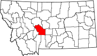
 Location in the U.S. state of Montana |
|
 Montana's location in the U.S. |
|
| Founded | November 16, 1867 |
| Named for | Thomas Francis Meagher |
| Seat | White Sulphur Springs |
| Largest city | White Sulphur Springs |
| Area | |
| • Total | 2,395 sq mi (6,203 km2) |
| • Land | 2,392 sq mi (6,195 km2) |
| • Water | 2.8 sq mi (7 km2), 0.1% |
| Population (est.) | |
| • (2015) | 1,830 |
| • Density | 0.8/sq mi (0/km²) |
| Congressional district | At-large |
| Time zone | Mountain: UTC-7/-6 |
| Website | www |
Meagher County (pronounced Marr) is a county located in the U.S. state of Montana. As of the 2010 census, the population was 1,891. Its county seat is White Sulphur Springs.
According to the U.S. Census Bureau, the 2010 center of population of Montana is located in Meagher County at 46°47′N 111°18′W / 46.78°N 111.3°W
Meagher County was named for Thomas Francis Meagher, territorial governor of Montana.
The first county seat was Diamond City, the main city of the Confederate Gulch mining district. This entire area is no longer part of Meagher County, but today lies in neighboring Broadwater County.
According to the U.S. Census Bureau, the county has a total area of 2,395 square miles (6,200 km2), of which 2,392 square miles (6,200 km2) is land and 2.8 square miles (7.3 km2) (0.1%) is water.
As of the census of 2000, there were 1,932 people, 803 households, and 529 families residing in the county. The population density was <1/km² (1/sq mi). There were 1,363 housing units at an average density of <1/km² (1/sq mi). The racial makeup of the county was 97.20% White, 1.04% Native American, 0.16% Asian, 0.05% Pacific Islander, 0.57% from other races, and 0.98% from two or more races. 1.50% of the population were Hispanic or Latino of any race. 28.8% were of German, 14.5% Norwegian, 13.3% English, 12.4% Irish and 7.8% American ancestry.
...
Wikipedia
