Mead Township, Pennsylvania
| Mead Township | |
|---|---|
| Township | |
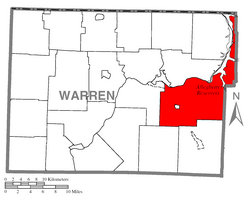
 Location of Mead Township in Warren County |
|
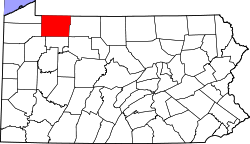
 Location of Warren County in Pennsylvania |
|
| Country | United States |
| State | Pennsylvania |
| County | Warren County |
| Area | |
| • Total | 85.8 sq mi (222 km2) |
| • Land | 78.5 sq mi (203 km2) |
| • Water | 7.2 sq mi (19 km2) |
| Population (2000) | |
| • Total | 1,555 |
| • Density | 18/sq mi (7.0/km2) |
| Time zone | EST (UTC-4) |
| • Summer (DST) | EDT (UTC-5) |
| Area code(s) | 814 |
Mead Township is a township in Warren County, Pennsylvania, United States. The population was 1,555 at the 2000 census.
Mead Township was created on June 7, 1847 from parts of Sheffield, Kinzua, and Pleasant Townships. It was named for early 19th-century settler Darius Mead.
In the early 1960s, construction began on the Kinzua Dam and a few small communities on the banks of the Allegheny River were evacuated and flooded. The nearby townships of Kinzua and Corydon, having greatly reduced populations, were merged into Mead in 1963 and 1964, respectively.
According to the United States Census Bureau, the township has a total area of 85.8 square miles (222.1 km²), of which, 78.5 square miles (203.3 km²) of it is land and 7.2 square miles (18.8 km²) of it (8.45%) is water. It is the largest township by area in Warren County.
The Allegheny Reservoir forms the entire western border of Mead Township's northern arm.
The Borough of Clarendon is enclaved within the Township.
As of the census of 2000, there were 1,555 people, 649 households, and 456 families residing in the township. The population density was 19.8 people per square mile (7.6/km²). There were 878 housing units at an average density of 11.2/sq mi (4.3/km²). The racial makeup of the township was 99.10% White, 0.06% African American, 0.06% Asian, 0.06% Pacific Islander, and 0.71% from two or more races. Hispanic or Latino of any race were 0.26% of the population.
...
Wikipedia
