McIntosh, South Dakota
|
McIntosh, South Dakota Maktáža |
|
|---|---|
| City | |
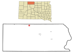
 Location within Corson County and South Dakota |
|
| Coordinates: 45°55′18″N 101°21′1″W / 45.92167°N 101.35028°WCoordinates: 45°55′18″N 101°21′1″W / 45.92167°N 101.35028°W | |
| Country | United States |
| State | South Dakota |
| County | Corson |
| Area | |
| • Total | 0.77 sq mi (1.99 km2) |
| • Land | 0.73 sq mi (1.89 km2) |
| • Water | 0.04 sq mi (0.10 km2) |
| Elevation | 2,316 ft (706 m) |
| Population (2010) | |
| • Total | 173 |
| • Estimate (2012) | 175 |
| • Density | 237.0/sq mi (91.5/km2) |
| Time zone | Mountain (MST) (UTC-7) |
| • Summer (DST) | MDT (UTC-6) |
| ZIP code | 57641 |
| Area code(s) | 605 |
| FIPS code | 46-39940 |
| GNIS ID | 1256381 |
McIntosh (Lakota: Maktáža) is a city in and the county seat of Corson County, South Dakota, United States. The population was 173 at the 2010 census.
McIntosh was named for a sibling duo who worked for the railroad.
McIntosh is located at 45°55′18″N 101°21′1″W / 45.92167°N 101.35028°W (45.921649, -101.350171). According to the United States Census Bureau, the city has a total area of 0.77 square miles (1.99 km2), of which, 0.73 square miles (1.89 km2) is land and 0.04 square miles (0.10 km2) is water. McIntosh has been assigned the ZIP code 57641 and the FIPS place code 39940.
McIntosh holds the record for the coldest record temperature in South Dakota (-58 degrees Fahrenheit), set February 17, 1936.
That same year, McIntosh set its own record for highest temperature (114 ºF) that stands to this day.
As of the census of 2010, there were 173 people. The city had 84 households, and 49 families residing in the city. Between 2000 and 2010, the city's population declined by 20%. The population density was 237.0 inhabitants per square mile (91.5/km2). There were 111 housing units at an average density of 152.1 per square mile (58.7/km2).
Racially, the city has 132 White people, 33 Native Americans, 4 of Hispanic or Latino decent, 1 Asian, and 3 from other races.
...
Wikipedia
