McCloud, California
| McCloud | |
|---|---|
| census-designated place | |

Deep snow in McCloud, with Mount Shasta in the background
|
|
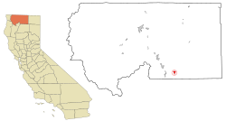
 Location in Siskiyou County and the state of California |
|
| Location in the United States | |
| Coordinates: 41°15′17″N 122°8′11″W / 41.25472°N 122.13639°WCoordinates: 41°15′17″N 122°8′11″W / 41.25472°N 122.13639°W | |
| Country | |
| State |
|
| County |
|
| Area | |
| • Total | 2.488 sq mi (6.444 km2) |
| • Land | 2.422 sq mi (6.274 km2) |
| • Water | 0.066 sq mi (0.171 km2) 2.65% |
| Elevation | 3,271 ft (997 m) |
| Population (2010) | |
| • Total | 1,101 |
| • Density | 440/sq mi (170/km2) |
| Time zone | Pacific (PST) (UTC-8) |
| • Summer (DST) | PDT (UTC-7) |
| ZIP code | 96057 |
| Area code(s) | 530 |
| FIPS code | 06-44784 |
| GNIS feature ID | 0277555 |
McCloud is a small town and census-designated place (CDP) in Siskiyou County, California, United States. The population was 1,101 at the 2010 census, down from 1,343 at the 2000 census.
Located in the Shasta Cascade area of Northern California, McCloud sees many visitors. Visitors use McCloud as a base to engage in nationally recognized trout fishing in the nearby McCloud,Sacramento and Klamath Rivers, or come to see and climb Mount Shasta, Castle Crags or the Trinity Alps. Visitors also engage in nearby skiing (both alpine and cross-country), biking or hiking to the waterfalls, streams and lakes in the area, including nearby Falls of the McCloud River, Burney Falls, Mossbrae Falls, Lake Siskiyou, Castle Lake and Shasta Lake, or visiting the ruins of one of the great nightclubs or speakeasies from the heyday of the Roaring Twenties.
McCloud is located at 41°15′17″N 122°8′11″W / 41.25472°N 122.13639°W (41.254682, -122.136321) on the southern slope of Mount Shasta, at an elevation of 3,271 feet (997 m) above sea level.
...
Wikipedia

