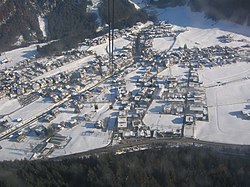
Mayrhofen
| Mayrhofen | ||
|---|---|---|
 |
||
|
||
| Location within Austria | ||
| Coordinates: 47°10′N 11°52′E / 47.167°N 11.867°ECoordinates: 47°10′N 11°52′E / 47.167°N 11.867°E | ||
| Country | Austria | |
| State | Tyrol | |
| District | Schwaz | |
| Government | ||
| • Mayor | Günter Fankhauser | |
| Area | ||
| • Total | 178.78 km2 (69.03 sq mi) | |
| Elevation | 633 m (2,077 ft) | |
| Population (1 January 2016) | ||
| • Total | 3,794 | |
| • Density | 21/km2 (55/sq mi) | |
| Time zone | CET (UTC+1) | |
| • Summer (DST) | CEST (UTC+2) | |
| Postal code | 6290 | |
| Area code | 05285 | |
| Vehicle registration | SZ | |
| Website | www.mayrhofen.at | |
| Mayrhofen | ||||||||||||||||||||||||||||||||||||||||||||||||||||||||||||
|---|---|---|---|---|---|---|---|---|---|---|---|---|---|---|---|---|---|---|---|---|---|---|---|---|---|---|---|---|---|---|---|---|---|---|---|---|---|---|---|---|---|---|---|---|---|---|---|---|---|---|---|---|---|---|---|---|---|---|---|---|
| Climate chart () | ||||||||||||||||||||||||||||||||||||||||||||||||||||||||||||
|
||||||||||||||||||||||||||||||||||||||||||||||||||||||||||||
|
||||||||||||||||||||||||||||||||||||||||||||||||||||||||||||
| J | F | M | A | M | J | J | A | S | O | N | D |
|
55
1
−4
|
46
4
−3
|
63
10
0
|
74
14
3
|
97
20
8
|
131
22
11
|
149
24
13
|
131
23
12
|
97
19
9
|
65
14
5
|
75
6
0
|
62
1
−3
|
| Average max. and min. temperatures in °C | |||||||||||
| Precipitation totals in mm | |||||||||||
| Source: ZAMG | |||||||||||
| Imperial conversion | |||||||||||
|---|---|---|---|---|---|---|---|---|---|---|---|
| J | F | M | A | M | J | J | A | S | O | N | D |
|
2.2
34
25
|
1.8
39
27
|
2.5
50
32
|
2.9
57
37
|
3.8
68
46
|
5.2
72
52
|
5.9
75
55
|
5.2
73
54
|
3.8
66
48
|
2.6
57
41
|
3
43
Wikipedia
...
| |


