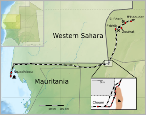
Mauritania Railway
| Mauritania Railway | ||||||||||||||||||||||||||||||||||||||||||||||||||||||||||||||||||||||||||||||||||||||||||||||||||||||||||||||||||||||||||||||||||||||||||||||||||
|---|---|---|---|---|---|---|---|---|---|---|---|---|---|---|---|---|---|---|---|---|---|---|---|---|---|---|---|---|---|---|---|---|---|---|---|---|---|---|---|---|---|---|---|---|---|---|---|---|---|---|---|---|---|---|---|---|---|---|---|---|---|---|---|---|---|---|---|---|---|---|---|---|---|---|---|---|---|---|---|---|---|---|---|---|---|---|---|---|---|---|---|---|---|---|---|---|---|---|---|---|---|---|---|---|---|---|---|---|---|---|---|---|---|---|---|---|---|---|---|---|---|---|---|---|---|---|---|---|---|---|---|---|---|---|---|---|---|---|---|---|---|---|---|---|---|---|
|
Map of Mauritania Railway
|
||||||||||||||||||||||||||||||||||||||||||||||||||||||||||||||||||||||||||||||||||||||||||||||||||||||||||||||||||||||||||||||||||||||||||||||||||
| Line length: | 704 km (437 mi) | |||||||||||||||||||||||||||||||||||||||||||||||||||||||||||||||||||||||||||||||||||||||||||||||||||||||||||||||||||||||||||||||||||||||||||||||||
| Track gauge: | 1,435 mm (4 ft 8 1⁄2 in) standard gauge | |||||||||||||||||||||||||||||||||||||||||||||||||||||||||||||||||||||||||||||||||||||||||||||||||||||||||||||||||||||||||||||||||||||||||||||||||
|
||||||||||||||||||||||||||||||||||||||||||||||||||||||||||||||||||||||||||||||||||||||||||||||||||||||||||||||||||||||||||||||||||||||||||||||||||
The Mauritania Railway is the national railway of Mauritania. Opened in 1963, it consists of a single, 704-kilometre (437 mi) railway line linking the iron mining centre of Zouerate with the port of Nouadhibou, via Fderik and Choum. The state agency Société Nationale Industrielle et Minière (National Mining and Industrial Company, SNIM) controls the railway line.
Since the closure of the Choum Tunnel, a 5 km (3.1 mi) section of the railway cuts through the Polisario Front-controlled part of the Western Sahara (21°21′18″N 13°00′46″W / 21.354867°N 13.012644°W).
Trains on the railway are up to 2.5 kilometres (1.6 mi) in length, making them among the longest and heaviest in the world. They consist of 3 or 4 diesel-electric EMD locomotives, 200 to 210 cars each carrying up to 84 tons of iron ore, and a variable number of service cars. The total traffic averages 16.6 million tons per year.
Passengers are also occasionally transported by train; these services are managed by an SNIM subsidiary, the ATTM Society (Société d'assainissement, de travaux, de transport et de maintenance). Passenger cars are sometimes attached, but more often passengers simply ride atop the ore hopper cars.
In October 2010, SNIM ordered a batch of six EMD SD-70ACS locomotives, with special modifications for operating in high temperatures.
...
Wikipedia

