Matukutururu
| Wiri Mountain | |
|---|---|
| Te Manurewa O Tamapahore | |

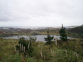
The quarried remains of Matukutūruru, when part-filled with water. Picture is taken from some of the higher remnants.
|
|
| Highest point | |
| Elevation | 80 m (260 ft) |
| Coordinates | 37°00′26″S 174°51′30″E / 37.007334°S 174.858441°ECoordinates: 37°00′26″S 174°51′30″E / 37.007334°S 174.858441°E |
| Geography | |
| Location | Wiri, North Island, New Zealand |
| Geology | |
| Volcanic arc/belt | Auckland volcanic field |
Matukutūruru (also Te Manurewa O Tamapahore or Wiri Mountain) is a volcano in Wiri, in the Auckland volcanic field. It had a scoria cone reaching 80 metres above sea level (around 50 m higher than the surrounding land), which was quarried away. The lava flows created 290m long Wiri Lava Cave. The hill was the site of a pā. In late 2011 the quarry lake was drained and fill-dumping began on the site.
Matukutūruru and nearby Matukutūreia are collectively known as Matukurua (also Ngā Matukurua).
The quarried remnants of Wiri Mountain as seen from Matukutūreia.
Wiri quarry when part-filled with water, looking toward Matukutūreia.
...
Wikipedia
