Mattstetten
| Mattstetten | ||
|---|---|---|

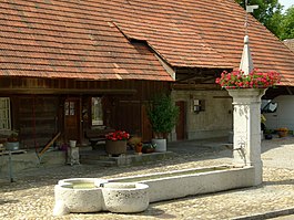
Mattstetten village fountain
|
||
|
||
| Coordinates: 47°2′N 7°31′E / 47.033°N 7.517°ECoordinates: 47°2′N 7°31′E / 47.033°N 7.517°E | ||
| Country | Switzerland | |
| Canton | Bern | |
| District | Bern-Mittelland | |
| Area | ||
| • Total | 3.8 km2 (1.5 sq mi) | |
| Elevation | 516 m (1,693 ft) | |
| Population (Dec 2015) | ||
| • Total | 561 | |
| • Density | 150/km2 (380/sq mi) | |
| Postal code | 3322 | |
| SFOS number | 0543 | |
| Surrounded by | Bäriswil, Bolligen, Hindelbank, Jegenstorf, Krauchthal, Münchringen, Urtenen-Schönbühl | |
| Website |
http://www.mattstetten.ch SFSO statistics |
|
Mattstetten is a municipality in the Bern-Mittelland administrative district in the canton of Bern in Switzerland.
Mattstetten is first mentioned in 1201 as Mahtsteten.
During the Middle Ages, Ministerialis (unfree knights in the service of a feudal overlord) family of Mattstetten built a tower in the village. The family held the village as a fief for the Dukes of Zähringen and then the Counts of Kyburg. In the 14th century the village and surrounding land was held by the Knightly family of Rohrmoos. In the 15th century it was combined with Urtenen and was held by several Bernese patrician families including; the Diesbachs, the Bonstettens, the Willadings and the Erlachs. The local low court was in Urtenen, while the high court was in Zollikofen.
In 1831 a village school was built. Previously students had attended school in Urtenen. The fields around the village were often flooded by the Urtenen river until the river channel was deepened (in 1780, 1855 and 1917) and levees were built in 1944-46. While the village remained generally rural and agrarian the population slowly grew. In 1965 the new neighborhoods of Schulhausbitz, Neumatt and Breite were built for the new residents. Today many of the residents commute to jobs in Bern.
Mattstetten has an area of 3.8 km2 (1.47 sq mi). Of this area, 1.89 km2 (0.73 sq mi) or 49.7% is used for agricultural purposes, while 1.28 km2 (0.49 sq mi) or 33.7% is forested. Of the rest of the land, 0.58 km2 (0.22 sq mi) or 15.3% is settled (buildings or roads), 0.04 km2 (9.9 acres) or 1.1% is either rivers or lakes.
Of the built up area, industrial buildings made up 1.6% of the total area while housing and buildings made up 5.0% and transportation infrastructure made up 7.4%. Power and water infrastructure as well as other special developed areas made up 1.3% of the area Out of the forested land, all of the forested land area is covered with heavy forests. Of the agricultural land, 44.2% is used for growing crops and 5.0% is pastures. All the water in the municipality is flowing water.
...
Wikipedia


