Matsumae, Hokkaido
|
Matsumae 松前町 |
||
|---|---|---|
| Town | ||
| Japanese transcription(s) | ||
| • Hepburn romanization | Matsumae-chō | |

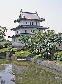
Matsumae Castle (July 2004)
|
||
|
||
 The location of Matsumae in Oshima Subprefecture. |
||
| Location of Matsumae in Japan | ||
| Coordinates: 41°26′N 140°7′E / 41.433°N 140.117°ECoordinates: 41°26′N 140°7′E / 41.433°N 140.117°E | ||
| Country | Japan | |
| Prefecture | Hokkaido | |
| Subprefecture | Oshima Subprefecture | |
| District | Matsumae | |
| Government | ||
| • Mayor (町長 chōchō?) | Hideo Ishiyama (石山 英雄?) | |
| Area | ||
| • Total | 293.11 km2 (113.17 sq mi) | |
| Population (2016-09-30) | ||
| • Total | 7,843 | |
| • Density | 27/km2 (69/sq mi) | |
| Post code | 049-1592 | |
| Area code(s) | 0139 | |
| Official Tree | Pine | |
| Official Flower | Cherry blossom | |
| Government Office Address | Aza Fukiyama 248, Matsumae-chō, Matsumae-gun, Hokkaidō 049-1592 | |
| Government Office Telephone | 0139-42-2275 | |
| Community Identification Number | 01331-5 | |
| Website | http://www.e-matsumae.com | |
Matsumae (松前町 Matsumae-chō?) is a town located in Matsumae District, Oshima Subprefecture, Hokkaido, Japan. The former home of the Matsumae Han, it has an Edo period castle, Matsumae Castle, the only one in Hokkaido, and Ryūun-in.
The total area of the town is 293.11 square kilometres (113.17 sq mi).
The town is located on the southern end of the Matsumae Peninsula. In addition the town governs the two islands in the Tsugaru Strait, Oshima and Kojima.
As of September 2016, the town has an estimated population of 7,843 and a density of 26.7 persons per km².
...
Wikipedia


