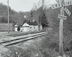
Matoaka, West Virginia
| Matoaka, West Virginia | |
|---|---|
| Town | |

Matoaka
|
|
 Location in Mercer County and the state of West Virginia. |
|
| Coordinates: 37°25′7″N 81°14′31″W / 37.41861°N 81.24194°WCoordinates: 37°25′7″N 81°14′31″W / 37.41861°N 81.24194°W | |
| Country | United States |
| State | West Virginia |
| County | Mercer |
| Area | |
| • Total | 0.26 sq mi (0.67 km2) |
| • Land | 0.26 sq mi (0.67 km2) |
| • Water | 0 sq mi (0 km2) |
| Elevation | 2,359 ft (719 m) |
| Population (2010) | |
| • Total | 227 |
| • Estimate (2012) | 222 |
| • Density | 873.1/sq mi (337.1/km2) |
| Time zone | Eastern (EST) (UTC-5) |
| • Summer (DST) | EDT (UTC-4) |
| ZIP code | 24736 |
| Area code(s) | 304 |
| FIPS code | 54-52420 |
| GNIS feature ID | 1542868 |
Matoaka is a small town in Mercer County, West Virginia, United States. The population was 227 at the 2010 census. It is part of the Bluefield, WV-VA micropolitan area which has a population of 107,578. This town is named for Chief Powhatan's daughter Matoaka who was better known by her nickname "Pocahontas".
Matoaka is located at 37°25′7″N 81°14′31″W / 37.41861°N 81.24194°W (37.418741, -81.242028).
According to the United States Census Bureau, the town has a total area of 0.26 square miles (0.67 km2), all land.
The climate in this area has mild differences between highs and lows, and there is adequate rainfall year-round. According to the Köppen Climate Classification system, Matoaka has a marine west coast climate, abbreviated "Cfb" on climate maps.
As of the census of 2010, there were 227 people, 87 households, and 60 families residing in the town. The population density was 873.1 inhabitants per square mile (337.1/km2). There were 145 housing units at an average density of 557.7 per square mile (215.3/km2). The racial makeup of the town was 98.7% White, 0.4% African American, and 0.9% Asian.
...
Wikipedia
