Massachusetts Route 113
| Route 113 | ||||
|---|---|---|---|---|

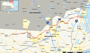
Map of northeastern Massachusetts with Route 113 highlighted in red
|
||||
| Route information | ||||
| Maintained by MassDOT | ||||
| Length: | 50.53 mi (81.32 km) | |||
| Existed: | by 1930 – present | |||
| Major junctions | ||||
| West end: |
|
|||
|
||||
| East end: |
|
|||
| Location | ||||
| Counties: | Middlesex, Essex | |||
| Highway system | ||||
|
||||
Route 113 is a west–east Massachusetts state route that connects towns in the Merrimack River valley in northeastern Massachusetts. Its western terminus is at Route 119 in Pepperell, and its eastern end is at U.S. Route 1 and Route 1A in Newburyport.
Route 113 begins at Route 119 in Pepperell. It heads eastward through the center of town, intersecting Route 111 and crossing the Nashua River before continuing westward into Dunstable. Route 113 acts as the main route through town, crossing the Salmon Brook before going through the town's center. It then enters Tyngsborough, where it meets U.S. Route 3 at Exit 35. At Middlesex Street, Route 113 becomes concurrent with Route 3A, passing over the Merrimack River with that route before splitting along a new alignment named Charles Chronopoulos Way, then turning southward along Pawtucket Boulevard.
As Pawtucket Boulevard, Route 113 follows the Merrimack into the city of Lowell. Once in Lowell, Route 113 acts as a parkway along the north bank of the river, intersecting the Rourke Bridge and the O'Donnell Bridge near the Pawtucket Falls before splitting from the parkway, which turns into the VFW Highway. Route 113 turns northward, crossing into Dracut. It crosses the Beaver Brook before intersecting with Route 38 near the town center. From there, Route 113 continues through a rural section of Dracut into Methuen and Essex County.
...
Wikipedia

