Marysville, Kansas
| Marysville, Kansas | |
|---|---|
| City | |

Marysville water tower (2009)
|
|
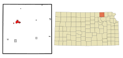
 Location within Marshall County and Kansas |
|
 KDOT map of Marshall County (legend) |
|
| Coordinates: 39°50′41″N 96°38′33″W / 39.84472°N 96.64250°WCoordinates: 39°50′41″N 96°38′33″W / 39.84472°N 96.64250°W | |
| Country | United States |
| State | Kansas |
| County | Marshall |
| Area | |
| • Total | 4.62 sq mi (11.97 km2) |
| • Land | 4.58 sq mi (11.86 km2) |
| • Water | 0.04 sq mi (0.10 km2) |
| Elevation | 1,161 ft (354 m) |
| Population (2010) | |
| • Total | 3,294 |
| • Estimate (2014) | 3,295 |
| • Density | 710/sq mi (280/km2) |
| Time zone | Central (CST) (UTC-6) |
| • Summer (DST) | CDT (UTC-5) |
| ZIP codes | 66508, 66555 |
| Area code | 785 |
| FIPS code | 20-45050 |
| GNIS feature ID | 0472911 |
| Website | City Website |
Marysville is a city in and the county seat of Marshall County, Kansas, United States. As of the 2010 census, the city population was 3,294.
Marysville was laid out in 1855 by Francis J. Marshall, and designated in that same year the county seat. It was incorporated as a city in 1861.
Marysville was located on the Oregon Trail and the route of the Pony Express, the St. Joe Road, the Overland Stage, The Military Road, and the Otoe-Missouria Trail. British explorer Richard Francis Burton en route to California in 1860 noted: "Passing by Marysville, in old maps Palmetto City, a country-town which thrives by selling whiskey to ruffians of all descriptions ..." The old Pony Express Station still stands in downtown Marysville.
Marysville owes much of its prosperity to the Union Pacific Railroad. The railroad has been a major employer in the town for nearly 100 years. Over 60 trains pass through the town daily and the railroad recently completed an underpass which redirects the tracks below US-36, rather than crossing the highway and backing up traffic.
Marysville is also known as the "Black Squirrel City" due to an isolated community of all-black squirrels that make their homes in the town. The squirrels are said to be the result of escapees from a traveling circus.
Marysville is located at 39°50′41″N 96°38′33″W / 39.84472°N 96.64250°W (39.844624, -96.642505). According to the United States Census Bureau, the city has a total area of 4.62 square miles (11.97 km2), of which 4.58 square miles (11.86 km2) is land and 0.04 square miles (0.10 km2) is water.
...
Wikipedia
