Maryland Route 936
| Maryland Route 936 | ||||
|---|---|---|---|---|

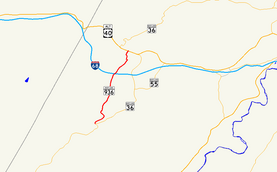
Maryland Route 936 highlighted in red
|
||||
| Route information | ||||
| Maintained by MDSHA | ||||
| Length: | 5.04 mi (8.11 km) | |||
| Existed: | 1972 – present | |||
| Major junctions | ||||
| South end: | Church Street in Midland | |||
| North end: |
|
|||
| Location | ||||
| Counties: | Allegany | |||
| Highway system | ||||
|
||||
Maryland Route 936 (MD 936) is a state highway in the U.S. state of Maryland. Known for most of its length as Upper Georges Creek Road, the state highway runs 5.04 miles (8.11 km) from Church Street in Midland north to U.S. Route 40 Alternate (US 40 Alternate) and MD 36 in Frostburg. MD 936 is the old alignment of MD 36 between Midland and Frostburg in the upper Georges Creek Valley of western Allegany County. The state highway was designated when MD 36 moved to a new alignment between the two communities in the early 1970s.
MD 936 begins at the intersection of Broadway Street and Church Street in the town of Midland. The state highway is connected to MD 36 (Main Street) by Church Street. MD 936 heads north as two-lane Upper Georges Creek Road paralleling Georges Creek and the Georges Creek Railway. The state highway passes through the small communities of Ocean, Klondike, Woodland, and Borden Shaft, where the railway reaches its northern terminus. MD 936 passes under Interstate 68 (I-68) without access, then enters a residential area. In the community of Grahamtown, the state highway passes through a very sharp S-curve. MD 936 veers to the northwest and enters the city of Frostburg at Green Street, where the highway becomes Grant Street. The state highway veers back north as it ascends a hill through a densely populated residential area to its northern terminus at US 40 Alternate and MD 36 (Main Street).
...
Wikipedia

