Maryland Route 281
| Maryland Route 281 | ||||
|---|---|---|---|---|

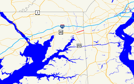
Maryland Route 281 highlighted in red
|
||||
| Route information | ||||
| Maintained by MDSHA | ||||
| Length: | 2.12 mi (3.41 km) | |||
| Existed: | 1933 – present | |||
| Major junctions | ||||
| West end: |
|
|||
|
|
||||
| East end: | Old Baltimore Pike at the Delaware state line near Elkton | |||
| Location | ||||
| Counties: | Cecil | |||
| Highway system | ||||
|
||||
Maryland Route 281 (MD 281) is a state highway in the U.S. state of Maryland. Known for most of its length as Red Hill Road, the state highway runs 2.12 miles (3.41 km) from MD 7 east to the Delaware state line in Elkton in northeastern Cecil County. MD 281 and its continuation in Delaware were originally blazed in the 18th century as part of the Old Post Road between Baltimore and Philadelphia. The route was part of the Elk and Christiana Turnpike in the early 19th century and later the Old Baltimore Pike, but it was replaced as the main highway east from Elkton by U.S. Route 40 (US 40) in the early 20th century. MD 281 was constructed in Elkton in the early 1930s. The highway designation was extended east to the state line in the late 1950s; that extension was reconstructed in the early 1960s.
MD 281 begins at an intersection with MD 7 in the town of Elkton. MD 7 continues west as Main Street and heads southeast as Delaware Avenue toward US 40. MD 281 heads east as two-lane Main Street and leaves the town by crossing Big Elk Creek. The highway continues as Red Hill Road, which passes to the north of Grays Hill. MD 281 meets the northern end of MD 781 (Delancy Road) before reaching its eastern terminus at the Delaware state line. The highway continues straight as Old Baltimore Pike toward Christiana.
...
Wikipedia

