Maryland Route 18
| Maryland Route 18 | ||||
|---|---|---|---|---|

Maryland Route 18 highlighted in red
|
||||
| Route information | ||||
| Maintained by MDSHA | ||||
| Length: | 20.37 mi (32.78 km) | |||
| Existed: | 1927 – present | |||
| Tourist routes: |
|
|||
| Major junctions | ||||
| West end: | Love Point | |||
|
|
||||
| East end: |
|
|||
| Location | ||||
| Counties: | Queen Anne's | |||
| Highway system | ||||
|
||||
![]() MD 8 in Stevensville
MD 8 in Stevensville![]() MD 552 in Chester
MD 552 in Chester![]() US 50 in Queenstown
US 50 in Queenstown
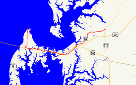
Maryland Route 18 (MD 18) is a state highway in the U.S. state of Maryland. The state highway runs 20.37 miles (32.78 km) from the beginning of state maintenance at Love Point east to MD 213 in Centreville. MD 18 is the main east–west local highway on Kent Island and east to Centreville, serving the centers of Stevensville, Chester, Kent Narrows, Grasonville, and Queenstown that are bypassed by U.S. Route 50 and US 301. What is signed as MD 18 is actually a set of four suffixed highways: MD 18A, MD 18B, MD 18S, and MD 18C. There are also several unsigned segments of MD 18 scattered along the length of the signed portions.
...
Wikipedia

