Martinsville, Ohio
| Martinsville, Ohio | |
|---|---|
| Village | |
 Location of Martinsville, Ohio |
|
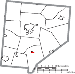
 Location of Martinsville in Clinton County |
|
| Coordinates: 39°19′23″N 83°48′40″W / 39.32306°N 83.81111°WCoordinates: 39°19′23″N 83°48′40″W / 39.32306°N 83.81111°W | |
| Country | United States |
| State | Ohio |
| County | Clinton |
| Area | |
| • Total | 0.44 sq mi (1.14 km2) |
| • Land | 0.44 sq mi (1.14 km2) |
| • Water | 0 sq mi (0 km2) |
| Elevation | 1,086 ft (331 m) |
| Population (2010) | |
| • Total | 463 |
| • Estimate (2012) | 463 |
| • Density | 1,052.3/sq mi (406.3/km2) |
| Time zone | Eastern (EST) (UTC-5) |
| • Summer (DST) | EDT (UTC-4) |
| ZIP code | 45146 |
| Area code(s) | 937 |
| FIPS code | 39-48118 |
| GNIS feature ID | 1043032 |
Martinsville is a village in Clinton County, Ohio, United States. The population was 463 at the 2010 census.
Martinsville was platted in 1816. By 1833, Martinsville had 75 inhabitants.
In 2013, prosecutors charged a former Martinsville council president and a village administrator with stealing more than $100,000 from the village.
Martinsville corporation limit sign
Looking east on West Main Street (Ohio Highway 28) in Martinsville
Martinsville is located at 39°19′23″N 83°48′40″W / 39.32306°N 83.81111°W (39.323042, -83.811003).
According to the United States Census Bureau, the village has a total area of 0.44 square miles (1.14 km2), all land.
As of the census of 2010, there were 463 people, 149 households, and 118 families residing in the village. The population density was 1,052.3 inhabitants per square mile (406.3/km2). There were 166 housing units at an average density of 377.3 per square mile (145.7/km2). The racial makeup of the village was 96.1% White, 1.3% African American, 0.2% Asian, and 2.4% from other races. Hispanic or Latino of any race were 2.8% of the population.
...
Wikipedia
