Martinez, Georgia
| Martinez, Georgia | |
|---|---|
| Census-designated place | |
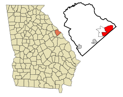
 Location in Columbia County and the state of Georgia |
|
| Coordinates: 33°30′58″N 82°6′0″W / 33.51611°N 82.10000°WCoordinates: 33°30′58″N 82°6′0″W / 33.51611°N 82.10000°W | |
| Country | United States |
| State | Georgia |
| County | Columbia |
| Area | |
| • Total | 14.6 sq mi (37.9 km2) |
| • Land | 14.5 sq mi (37.6 km2) |
| • Water | 0.1 sq mi (0.3 km2) |
| Elevation | 361 ft (110 m) |
| Population (2010) | |
| • Total | 35,795 |
| • Density | 2,467/sq mi (952.4/km2) |
| Time zone | Eastern (EST) (UTC-5) |
| • Summer (DST) | EDT (UTC-4) |
| ZIP code | 30907 |
| Area code(s) | 706 |
| FIPS code | 13-50036 |
| GNIS feature ID | 0332326 |
Martinez (/mɑːrtənˈɛz/) is a census-designated place (CDP) in Columbia County, Georgia, United States. It is a northwestern suburb of Augusta and is part of the Augusta, Georgia metropolitan area. The population was 35,795 at the 2010 census.
Martinez is located in eastern Columbia County at 33°30′58″N 82°6′0″W / 33.51611°N 82.10000°W (33.516089, -82.100024). It is bordered to the southeast by the city of Augusta in Richmond County. To the north and northwest is the CDP of Evans. Interstate 20 forms the short southern boundary of Martinez, with access from Exit 194 (Georgia State Route 383/South Belair Road).
According to the United States Census Bureau, the CDP has a total area of 14.6 square miles (37.9 km2), of which 14.5 square miles (37.6 km2) is land and 0.12 square miles (0.3 km2), or 0.76%, is water.
...
Wikipedia
